Nigeria: The 36 States
The 36 States & FCT
Federation · Geopolitical Zones · Local Governments
Explore the administrative architecture of Nigeria, divided into 36 semi-autonomous states and the Federal Capital Territory, organized into six geopolitical zones and 774 local government areas.
The anatomy of the
Federation
The Federal Republic of Nigeria is a federation of 36 states and one Federal Capital Territory (FCT), located in Abuja. Each state is a semi-autonomous political entity that shares sovereignty with the federal government under the Constitution.
The journey to the current 36-state structure is deeply rooted in Nigeria’s political history. At independence in 1960, the country consisted of just three massive regions (Northern, Western, and Eastern). To ease ethnic tensions and bring government closer to the grassroots, successive military governments divided these regions over several decades—ultimately finalizing the map of 36 states in 1996.
Today, states are further grouped into six unofficial but highly significant Geopolitical Zones, which dictate power-sharing, federal character quotas, and broad regional identities. Below the state level, the country is subdivided into 774 Local Government Areas (LGAs).
- Executive Power: Wielded by an elected State Governor.
- Legislative Power: Vested in a unicameral State House of Assembly.
- Judiciary: State High Courts and Customary/Sharia courts.
- Revenue: States rely on internal revenue and Federal allocations (FAAC).
State highlights
The extremes and economic hubs of the federation
Explore the Zones
States grouped by historical, cultural, and political ties
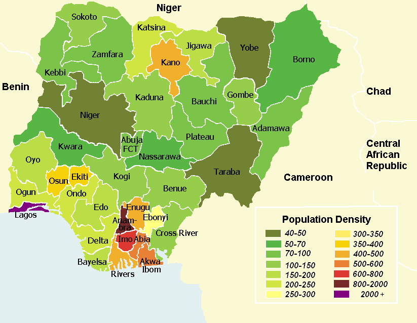
Political map detailing the boundaries of Nigeria’s 36 states and Abuja.
| 1960 | 3 Regions (Northern, Western, Eastern). |
|---|---|
| 1963 | 4 Regions (Mid-Western Region created). |
| 1967 | 12 States created by Gen. Yakubu Gowon. |
| 1976 | 19 States created by Gen. Murtala Mohammed. |
| 1987 | 21 States created by Gen. Ibrahim Babangida. |
| 1991 | 30 States created by Gen. Ibrahim Babangida. |
| 1996 | 36 States finalized by Gen. Sani Abacha. |
State Governance
How the federating units operate
Each of the 36 states is led by an Executive Governor, elected for a maximum of two four-year terms. Governors hold substantial power, managing state budgets, infrastructure, education, and healthcare within their jurisdictions. They are assisted by a Deputy Governor and a State Executive Council (Commissioners).
Unlike the bicameral federal National Assembly, state legislatures are unicameral bodies known as the State House of Assembly. Representatives are elected from constituencies within the state to pass local laws, approve budgets, and exercise oversight over the state’s executive branch.
The third tier of government consists of 774 Local Government Areas (LGAs). Headed by elected Chairmen and local councilors, LGAs are meant to bring governance to the grassroots. However, their autonomy and financial independence from state governors remain major topics of political debate.
Though not explicitly enshrined in the Constitution, the 6 Geopolitical Zones (NW, NE, NC, SW, SE, SS) dictate the unwritten rules of Nigerian politics. “Zoning” ensures that top political offices (like the Presidency) rotate between the North and South, and across these six zones, to maintain ethnic and regional harmony.
Zones & Notable States
A breakdown of the federating units
| Zone | No. of States | Key Urban Centers |
|---|---|---|
| North West | 7 | Kano, Kaduna, Sokoto |
| North East | 6 | Maiduguri, Bauchi, Yola |
| North Central | 6 (+ FCT) | Jos, Ilorin, Makurdi |
| South West | 6 | Lagos, Ibadan, Abeokuta |
| South South | 6 | Port Harcourt, Uyo, Benin City |
| South East | 5 | Enugu, Onitsha, Owerri |
| State | Capital | Known For |
|---|---|---|
| Lagos | Ikeja | Commercial & Financial capital. |
| Kano | Kano | Commerce, history, population. |
| Rivers | Port Harcourt | Oil & Gas production hub. |
| Oyo | Ibadan | Agriculture, education, massive landmass in SW. |
| Delta | Asaba | Oil, ports, and diverse ethnicities. |