Now Reading: The Comprehensive Geography of Nigeria: A Multidimensional Analysis
-
01
The Comprehensive Geography of Nigeria: A Multidimensional Analysis

I. Executive Summary
Nigeria, officially the Federal Republic of Nigeria, stands as the most populous nation in Africa and the sixth most populous globally, occupying a pivotal position in West Africa. Its vast land area of 923,768 sq km encompasses a remarkable array of physical landscapes, ranging from the humid equatorial climate and dense rainforests of the south to the arid Sahelian conditions and expansive savannas of the north. This profound geographical diversity profoundly shapes its climate, ecosystems, natural resource distribution, and human settlement patterns.
The nation’s topography transitions from southern lowlands and coastal plains, through central hills and plateaus like the mineral-rich Jos Plateau, to the northern plains and eastern highlands. Dominating its hydrology are the Niger and Benue rivers, whose confluence forms a distinctive ‘Y’ shape and feeds the expansive Niger Delta, a critical ecological and economic zone.
Nigeria’s geological history, rooted in Precambrian crystalline basement rocks and Cretaceous-Cenozoic sedimentary basins, including the tectonically significant Benue Trough, has endowed it with abundant natural resources. These include vast reserves of petroleum and natural gas, alongside diverse solid minerals such as tin, columbite, iron ore, coal, limestone, gold, and various gemstones.
The country’s human geography is characterized by a rapidly growing, young, and highly urbanizing population. With 36 states and a Federal Capital Territory, Nigeria is a melting pot of over 371 ethnic groups and 500 languages, reflecting a rich cultural tapestry. The distribution of its population is influenced by historical factors, resource availability, and administrative centers.
Despite its immense resource wealth, particularly from the oil industry, Nigeria faces significant environmental challenges, most acutely in the Niger Delta, where oil spills and gas flaring have led to widespread pollution, ecosystem degradation, and socio-economic distress. Broader issues like soil degradation, deforestation, and urban pollution also pose substantial threats to sustainable development. This report provides a comprehensive analysis of these geographical facets, their interdependencies, and their profound implications for Nigeria’s development trajectory.
II. Introduction: Nigeria’s Geographic Significance
Nigeria’s geographical attributes position it as a country of considerable regional and global importance. Its location, size, and physical features collectively shape its economic, social, and environmental landscape.
Geographical Location and Strategic Context in West Africa
Nigeria, officially known as the Federal Republic of Nigeria, holds the distinction of being the most populous nation on the African continent. Situated in West Africa, its borders are defined by the Gulf of Guinea to the south, the Republic of Benin to the west, Chad and Cameroon to the east, and Niger to the north. This geographical placement is not merely a descriptive fact; it underpins Nigeria’s role as a significant regional power. The country’s extensive coastline along the Gulf of Guinea provides direct access to international maritime trade routes, conferring upon it the inherent potential of a maritime power.
The nation’s strategic location, bordering multiple West African nations and possessing direct access to the Atlantic Ocean, contributes to its standing as a regional hegemon. Its substantial population, coupled with significant natural resources like oil and gas, allows Nigeria to exert considerable influence over its neighbors. The shared borders with Niger, Chad, and Cameroon place Nigeria at a critical juncture, intersecting with Sahelian security concerns and Central African dynamics. Simultaneously, its western border with Benin firmly integrates it within the economic and political framework of the West African sub-region, particularly the Economic Community of West African States (ECOWAS). This intricate web of connections means that Nigeria’s internal stability or instability can generate ripple effects across the entire sub-continent, making its domestic developments a matter of international interest and concern.
Official Name, Capital, and Administrative Overview
The nation is formally recognized as the Federal Republic of Nigeria. The administrative capital, Abuja, was relocated from Lagos in 1991, chosen for its centrally located position within the country. This strategic shift of the capital from the bustling coastal city of Lagos to the more geographically central Abuja represented a deliberate governmental effort to establish a more neutral and accessible administrative hub. This move was intended to foster national unity and to decentralize political and economic influence from Lagos, which had historically dominated the country’s affairs.
Nigeria operates under a bicameral system of government and is structured into 36 states, alongside the Federal Capital Territory (FCT). The FCT, distinct from the states, functions as a territory under the direct purview of the federal government, administered by a minister. Each of these states is further subdivided into local government areas (LGAs), totaling 774 LGAs across the nation. While the states are granted substantial autonomy under the Nigerian Constitution, the ultimate authority and sovereignty reside with the federal government. This layered administrative framework, with its balance between state autonomy and federal oversight, is designed to manage the country’s vast and diverse population effectively. The central positioning of Abuja is intended to facilitate more equitable administration across Nigeria’s varied regions, potentially mitigating regional imbalances and promoting a more cohesive national identity, although the practical efficacy of this arrangement remains subject to ongoing political and social dynamics.
Geographic Coordinates, Area, and Comparative Size
Nigeria’s geographic coordinates are approximately 10° N, 8° E , with more precise coordinates for its center being 9.0820°N 8.6753°E. The country encompasses a total area of 923,768 sq km , of which 910,768 sq km is land and 13,000 sq km is water.
To provide a comparative understanding of its scale, Nigeria is slightly smaller than South Australia, marginally smaller than British Columbia, and approximately three times the size of New Mexico. Another comparison highlights its size as roughly twice that of California. Furthermore, Nigeria is notably 94% larger than its eastern neighbor, Cameroon. The sheer expanse of Nigeria’s landmass presents considerable challenges in terms of governance, infrastructure development, and the sustainable management of its diverse resources. A territory of this magnitude, characterized by varied climates and terrains, necessitates distinct approaches to agriculture, urban planning, and environmental protection. For instance, the strategies required to combat desertification in the arid northern regions differ significantly from those needed to address oil pollution in the southern coastal areas, each demanding substantial resources and tailored interventions. Consequently, the vastness of the country, combined with its large and rapidly growing population, means that any national policy or environmental challenge inherently operates on a massive scale, requiring robust, adaptable governance structures and substantial financial investment to achieve effective outcomes.
Borders (Land and Maritime Claims) and Coastline
Nigeria shares a total of 4,047 km of land boundaries with its neighbors. The lengths of these borders are: Benin (773 km), Cameroon (1,690 km), Chad (87 km), and Niger (1,497 km). It is important to note that another source indicates slightly different figures for total land boundary at 4,477 km, with individual lengths being Benin (809 km), Cameroon (1,975 km), Chad (85 km), and Niger (1,608 km). These extensive land borders facilitate significant cross-border interactions, including trade, cultural exchange, and migration. However, they also present considerable security challenges, such as the movement of insurgent groups and illicit trade activities.
To the south, Nigeria boasts an 853 km coastline along the Gulf of Guinea in the Atlantic Ocean. This extensive maritime frontage is crucial for international trade, providing access to global markets and enabling the export of key resources like oil. The country’s maritime claims extend to a territorial sea of 12 nautical miles (nm), an exclusive economic zone (EEZ) of 200 nm, and a continental shelf defined by the 200-meter depth contour or to the depth of exploitation. The surface area of this continental shelf is substantial, measuring 46,300 km². These maritime zones are vital for the exploitation of offshore oil and gas reserves, which form the bedrock of Nigeria’s economy. The vastness of these maritime claims also necessitates a robust naval presence and effective maritime security strategies to protect national interests and combat piracy or other illicit activities. The combination of extensive land borders and significant maritime claims underscores Nigeria’s complex regional connectivity and its vulnerabilities, emphasizing that effective border management and robust regional cooperation are indispensable for both its economic prosperity and national security.
Table 1: Key Geographic Facts of Nigeria
| Feature | Detail | Source |
| Official Name | Federal Republic of Nigeria | |
| Capital City | Abuja | |
| Geographic Coordinates | 10° N, 8° E (approx.); 9.0820°N 8.6753°E (precise) | |
| Total Area | 923,768 sq km | |
| Land Area | 910,768 sq km | |
| Water Area | 13,000 sq km | |
| Coastline Length | 853 km | |
| Total Land Boundaries | 4,047 km (also cited as 4,477 km) | |
| Border Countries (lengths) | Benin: 773 km (or 809 km) | |
| Cameroon: 1,690 km (or 1,975 km) | ||
| Chad: 87 km (or 85 km) | ||
| Niger: 1,497 km (or 1,608 km) | ||
| Lowest Point | Atlantic Ocean (0 m) | |
| Highest Point | Chappal Waddi (2,419 m) |
This table serves as a foundational data reference, consolidating fundamental geographic information about Nigeria from various sources. By presenting these key facts upfront, the report establishes a clear baseline for understanding the country’s scale and fundamental characteristics. This consolidated view allows for immediate comprehension of Nigeria’s physical dimensions and its position relative to neighboring countries and global benchmarks. It also highlights minor discrepancies in data from different sources, such as the total land boundary length, which can be further discussed in the narrative to ensure accuracy and transparency in reporting.
III. Physical Geography: Foundations of the Nigerian Landscape
Nigeria’s diverse topography, intricate hydrological systems, and complex geological history form the foundational elements of its varied landscapes, influencing everything from climate patterns to resource distribution and human settlement.
A. Topography and Terrain: A Regional Analysis
Nigeria’s terrain is remarkably varied, generally transitioning from extensive plains in the north and south to a central belt of plateaus and hills. This topographical diversity is a defining feature of the country.
Southern Lowlands and Coastal Plains
The southern lowlands of Nigeria gradually merge into the central hills and plateaus. This coastal plain, stretching from the border with Benin to the Niger Delta, averages approximately 80 km in width. The southeastern coastal region consists of low sedimentary plains, which are essentially an extension of the southwestern coastal plains. The Atlantic coastline in this area is characterized by a series of sandbars, which are backed by lagoons of brackish water that provide an environment conducive to the growth of mangroves. Significant portions of Africa’s Bight of Benin and Bight of Biafra lie along this coast.
A notable feature of this coastline is its relatively straight configuration, attributed to the Guinea Current, which transports and deposits substantial amounts of sand. This geological process results in few natural harbors, necessitating constant dredging to maintain navigability for shipping. The low-lying nature of these coastal plains, coupled with the dynamic processes of sand deposition and erosion, indicates a highly vulnerable coastline. This vulnerability is particularly pronounced in areas like the Niger Delta, which is not only a critical ecological zone but also the heart of Nigeria’s oil industry. The physical characteristics of the southern lowlands directly influence the feasibility and cost of port development and expose both coastal communities and vital economic infrastructure, especially oil facilities, to environmental risks such as erosion and the impacts of rising sea levels.
Central Hills and Plateaus
The central region of Nigeria is marked by a series of prominent highlands, including the Jos Plateau, Adamawa Plateau, Mambilla Plateau, and Obudu Plateau.
The Jos Plateau, situated near Nigeria’s geographic center, rises sharply from the surrounding plains to an average elevation of approximately 1,300 m. Its central area spans about 8,000 sq km, with an average elevation of 1,280 meters , and its highest peak reaches 1,829 m. The adjacent high plains often exceed 975 meters. This plateau is renowned for its distinctive rock formations and abundant mineral resources, with tin mining historically being a significant economic activity. It stands as Africa’s primary tin-mining region, also containing the world’s largest known deposits of columbite, an ore of niobium found in association with tin. Smaller quantities of tantalite, wolfram (tungsten), kaolin, zircon, and uranium are also extracted, with lead and iron ore found in its eastern and central parts.
The plateau’s mild climate and fertile volcanic soils are conducive to the cultivation of a variety of crops, including vegetables, fruits, and tubers. Staple foods like
acha (hungry rice), sorghum, and millet are grown, alongside cash crops such as potatoes, yams, and green vegetables for urban markets. Geologically, the Jos Plateau is composed of eroded gneiss formations interspersed with granite intrusions that form massifs, and it features numerous extinct volcanic cones surrounded by basaltic flows, particularly near Panyam, Vom, and Miango. Over 22 dormant to extinct volcanoes are present across the plateau. Its cool, rainy climate makes it the source of numerous rivers that feed into the Niger and Benue systems, as well as the Gongola River. The plateau’s steep, irregular southern slopes are home to many waterfalls, including the Gurara Falls, several of which have been harnessed for hydroelectric power generation. Historically, the absence of the tsetse fly at this elevation has attracted Fulani herdsmen, making it an important area for cattle rearing. The Jos Plateau has been inhabited since the Acheulean period of the Early African Stone Age and served as a refuge for non-Muslim groups during the Fulani jihad in the early 19th century. The high elevation of the Jos Plateau provides a cooler climate and freedom from the tsetse fly, directly influencing its suitability for cattle rearing and human settlement, unlike lower, tsetse-infested areas. Its unique geology has concentrated valuable minerals, driving mining activities for over a century. The radial river network and waterfalls offer hydroelectric potential, further leveraging its physical geography for economic development. This illustrates a clear link between specific geological and climatic features and the historical and current economic activities and population distribution in the region. The plateau functions as an advantageous zone for certain agricultural practices and a significant area for mineral exploitation, profoundly shaping its socio-economic fabric.
The Mambilla Plateau, located in the far eastern extremes of Nigeria, is another high plateau region characterized by distinct mountain vegetation.
Northern Plains and the Sahel
The northern part of Nigeria is predominantly an extensive savanna region, defined by grasslands, scattered trees, and shrubbery, which provides an ideal environment for herding cattle and cultivating grains. As one progresses further north, this savanna gradually transitions into the Sahel, a semi-arid zone that serves as a crucial transitional area between the vast Sahara Desert to the north and the more humid savannas to the south. The Sahel experiences sparse and unpredictable rainfall, which dictates that agricultural practices in this region primarily revolve around hardy, drought-resistant crops and extensive pastoralism.
The Sokoto Plains are situated in the northwestern corner of the country, while the Borno Plains in the northeastern corner extend towards the Lake Chad basin. North of the Niger Valley lie the high plains of Hausaland, an area characterized by relatively level topography, averaging about 800 m above sea level, with isolated granite outcroppings. The gradual transition from savanna to Sahel directly reflects the south-to-north decline in rainfall. This climatic gradient fundamentally dictates agricultural practices, favoring grains and herding in the savanna and drought-resistant crops and pastoralism in the Sahel. The inherent aridity and unpredictable rainfall in the Sahel make this region particularly vulnerable to periodic droughts and desertification, which significantly impacts food security and the livelihoods of its inhabitants. The environmental fragility of the northern plains, primarily driven by climatic conditions, thus creates substantial socio-economic challenges, including food insecurity and potential forced migration, which can contribute to regional instability.
Eastern Highlands and Mountain Ranges
The southeastern part of Nigeria is characterized by mountainous terrain. Along Nigeria’s border with Cameroon, these highlands include several distinct ranges and plateaus, such as the Mandara Mountains, the Shebeshi Mountains, the Alantika Mountains, and the Mambila Mountains. The highest point in Nigeria is Chappal Waddi (also known as Gangirwal), which reaches an elevation of 2,419 m (7,936 ft). This peak is located in the Adamawa mountains within the Gashaka-Gumti Public Park, Taraba State, near the border with Cameroon. Another significant peak, Dimlang (Vogel Peak), in the Shebeshi Mountains, stands at 2,042 m. The presence of these prominent mountain ranges along the eastern border with Cameroon suggests shared geological origins and potentially unique biodiversity due to the higher elevations and relative isolation. These highlands often function as natural barriers, influencing historical movements and cultural interactions, but also serve as potential corridors for cross-border activities. The existence of Nigeria’s highest points in this region indicates a distinct ecological zone, offering unique habitats and potentially cooler climates compared to the surrounding lowlands. These mountainous regions, while posing challenges for infrastructure development, likely harbor unique ecosystems and serve as important water sources, contributing significantly to the broader ecological health of the country. They also represent areas with considerable potential for ecotourism and specialized agricultural niches, further diversifying Nigeria’s geographic and economic landscape.
B. Hydrology: Major Rivers, Lakes, and Coastal Features
Nigeria’s hydrological landscape is dominated by its extensive river systems, particularly the Niger and Benue, which are vital arteries for the nation’s ecology, economy, and human settlements.
The Niger-Benue River System
The Niger and Benue rivers constitute Nigeria’s principal streams, with the country itself deriving its name from the Niger River. The broad, largely level valleys formed by these two rivers represent Nigeria’s most expansive physical region. The Niger River originates in the highlands of Guinea, specifically the Fouta Djallon Mountains , and enters Nigeria from the Northwest, flowing in a southeasterly direction. The Benue River, the longest tributary of the Niger, originates in northern Cameroon from the Adamaoua Massif and flows westward before entering Nigeria from the Northeast. It spans approximately 1,083 km in length.
The defining feature of this river system within Nigeria is the confluence of the Niger and Benue rivers at Lokoja, located in the South Central region. This convergence creates a distinctive “Y” shape on the map, from which the combined flow continues southward, ultimately emptying into the Atlantic Ocean at the vast Niger Delta. At their confluence, the Niger is about three-fourths of a mile wide, while the Benue is over a mile wide, forming a lake-like stretch of water approximately two miles wide, dotted with islands and sandbanks. A sandbar, however, crosses the Benue at its confluence with the Niger, limiting water depth to about 0.6 meters during minimal flow periods. The Niger River stretches over 2,000 km through various regions before reaching Nigeria, including rainforest areas in its southern Nigerian course. The Benue itself flows for 1,400 km before meeting the Niger. The Niger-Benue system is a transboundary river basin, flowing through multiple West African countries, highlighting the interconnectedness of water resources across the region.
The flood regime of the Niger River downstream of Niamey is bi-modal. The “black floods,” originating in the headwaters of the Niger, typically reach Nigeria in January-February, characterized by dark water color from solute-rich tributaries. The larger “white floods” occur from August to October, resulting from overland runoff of precipitation, primarily from the Malendo and Sokoto rivers, and are laden with kaolinitic colloids, giving the water a milky appearance. The Benue flood, originating in the Adamaoua Mountains, reaches its peak flow rates in August-September and joins the Niger in October. The pervasive influence of the Niger and Benue rivers, originating outside Nigeria’s borders and flowing through multiple countries, means that water resource management, flood control, and environmental health within Nigeria are intrinsically linked to upstream activities in other nations. The complex hydrological dynamics, including the distinct “black” and “white” flood phenomena, significantly influence agricultural cycles, navigation, and flood risk across the country. The presence of a sandbar at the confluence, which can impede navigation during low flow, directly impacts economic activities reliant on river transport. Consequently, effective management of these vital river systems necessitates robust international cooperation and presents both opportunities, such as hydroelectric power generation, irrigation, and transportation, and challenges, including flood management, water sharing agreements, and sediment transport. These rivers are not merely physical features; they are crucial arteries for life and economic activity, profoundly influencing settlement patterns and agricultural productivity throughout the nation.
The Niger Delta
The Niger Delta region, located in Nigeria’s coastal area, is a vast and intricate landscape characterized by extensive mangrove forests, swamps, and lagoons. This low-lying, swampy terrain, encompassing multiple channels through which the Niger River and its tributaries drain into the Atlantic Ocean, spans an area of 36,000 sq km. Another assessment indicates its landmass to be approximately 70,000 km², representing 7.5% of Nigeria’s total land area.
The delta is densely populated and forms the epicenter of Nigeria’s oil industry. Its geomorphological units are complex, including outer barrier island complexes adjacent to the Atlantic Ocean, a lower tidal floodplain comprising estuaries, mangroves, and creeks, and an upper freshwater riverine floodplain. The landscape is predominantly flat, formed by extensive silt deposits carried by the Niger River, with numerous meandering river branches. The soils within the delta vary significantly due to the shifting nature of rivers and creeks, ranging from sand and loam on old levees to heavy, water-logged clay in backswamps, and silty loam and clay on higher ground. Recognized as the largest delta in Africa and the third-largest globally, it is also the most extensive marshland in West and Central Africa. The unique geomorphology of the Niger Delta, characterized by its low-lying, swampy terrain and intricate network of channels, naturally creates an environment conducive to rich biodiversity, including Africa’s largest tract of mangrove forests. However, this same geography, coupled with the region’s immense oil reserves, has transformed it into the heart of Nigeria’s oil industry. The high population density of the delta means that the severe environmental challenges stemming from oil extraction, such as frequent oil spills and gas flaring, directly impact a large human population, leading to profound socio-economic and health consequences. This situation exemplifies a classic “resource curse,” where abundant natural wealth paradoxically leads to widespread environmental degradation and significant social conflict. The Niger Delta’s geography is thus a double-edged sword: a critical source of national wealth but simultaneously a site of profound environmental and social injustice, underscoring the urgent need for sustainable resource management and equitable development.
Other Significant Water Bodies
Beyond the Niger-Benue system, Nigeria features other significant water bodies that play crucial regional roles. Lake Chad, located in the northeast, forms part of Nigeria’s border. This transboundary lake is notable for its dramatic shrinkage over recent decades, a phenomenon attributed to a combination of climate change and increased human abstraction of water. The diminishing size of Lake Chad directly impacts the livelihoods of communities in the semi-arid northern regions that depend on it for water resources, agriculture, and fishing.
Kainji Lake, with an area of 1,243 km², stands as the largest lake entirely within Nigeria. This artificial lake, created by the Kainji Dam, is of considerable economic importance, primarily serving as a significant source of hydroelectric power generation for the country. It also plays a role in irrigation, inland navigation, and fisheries. These major water bodies are not merely static geographical features; they are dynamic systems whose health, water levels, and availability are critically important for regional water security, food production, and energy supply, particularly in the context of increasing population pressures and climate variability. Their ongoing management and conservation are essential for sustaining the ecological balance and supporting the socio-economic well-being of the surrounding regions.
C. Geological Foundations and Landform Evolution
Nigeria’s diverse landscapes are deeply rooted in its complex geological history, which spans billions of years and involves various rock formations and tectonic processes.
Precambrian Basement Complex
The geological formation of Nigeria commenced in the Archean and Proterozoic eons of the Precambrian, making its crystalline basement rocks among the oldest on Earth. These igneous and metamorphic rocks constitute more than half of Nigeria’s surface, forming the ancient, solid physical foundation of the country. The long history of denudation has exposed these intrusive igneous rocks and their complex structures.
These Precambrian rocks are the parent materials for a variety of distinctive residual hills found particularly in southwestern Nigeria. These include mesas, inselbergs, tors, and regolith hills. Inselbergs are the most common type, classified by their size and morphology into whalebacks, turtlebacks, bornhardts (symmetrical or perfectly domical), and castle kopjes. They often occur in clusters with higher density in granitic plutons but can also be scattered within various gneisses. Prominent examples that have become significant touristic resources include the Idanre hills and the famous Olumo Rock (a tor) in Abeokuta. The prevalence of these ancient Precambrian basement rocks indicates a long and complex geological history, leading to the formation of unique and striking landforms like inselbergs and tors. These features are not merely geological curiosities; their aesthetic appeal has transformed them into valuable touristic assets, highlighting how deep geological history can translate into present-day economic and cultural value. Nigeria’s rich geological heritage thus offers considerable opportunities for geotourism and scientific study, providing avenues for economic diversification beyond traditional extractive industries.
Sedimentary Basins
Complementing the ancient basement complex are extensive sedimentary rocks of Cretaceous and Cenozoic age, which fill the various basins and depressions within the basement landmass. These sedimentary formations are of paramount importance as they are the primary geological hosts for the accumulation of hydrocarbons, including oil and natural gas. The presence of these basins, with their specific geological structures, provides the necessary conditions for the entrapment and preservation of fossil fuel reserves. This geological characteristic is fundamental to Nigeria’s identity as a major oil-producing nation, directly influencing its national economy, its role in global energy markets, and its overall geopolitical standing.
Alluvial Deposits
Quaternary to Recent age alluvial deposits are widely distributed along Nigeria’s main river valleys, particularly the Niger and Benue rivers. These deposits vary from thin, discontinuous sandy beds to thick sedimentary units, reaching up to 15 km in width and 15–30 m in thickness along the river channels. They are also found along the courses of major ephemeral streams and in
fadamas (wetlands), especially prevalent in the northern parts of the country.
Alluvial deposits, due to the nutrient-rich sediments transported and deposited by floodwaters, are typically highly fertile. This inherent fertility directly supports extensive agricultural activities, particularly for crops such as rice and various vegetables. However, the nature of these deposits, ranging from sandy beds to thick sedimentary units, also implies that these areas are prone to seasonal flooding. While such flooding can be beneficial for specific types of agriculture, like
fadama farming, it also poses significant hazards, as evidenced by the periodic flooding mentioned as a natural hazard in Nigeria. These alluvial areas represent prime agricultural land, offering substantial food production potential. However, realizing this potential while mitigating risks necessitates careful flood management strategies, including the construction of protective infrastructure and the implementation of adaptive farming practices.
Tectonic Processes and the Benue Trough
The Niger Delta-Benue Trough region represents a geological feature of immense significance: a 1,500 km long, 50-150 km wide, intraplate northeast-southwest tectonic megastructure. This trough is filled with a thick sequence of continental and marine sediments, dating from the Lower Cretaceous to the Quaternary period. It forms an integral part of the mid-African rift system, with its origin directly linked to the opening of the South Atlantic Ocean and complex interplate movements within the African continent. More specifically, the genesis of the Benue Trough is connected to the initiation of the equatorial domain of the South Atlantic opening during the latest Jurassic-early Cretaceous period.
The structural evolution of the Benue Trough involved three principal stages:
- Graben opening stage: This phase occurred during the latest Jurassic-Aptian time, characterized by the development of normal faults and associated flexures.
- Sag stage: This period, spanning from the Albian through the Tertiary, involved continued subsidence and sediment accumulation within the trough.
- Compressional stage: This stage manifested during the Cenomanian and more intensely during the late Santonian-early Campanian. This compressional event resulted in the formation of a distinct belt of folds, striking parallel to the trough borders, known as the Abakaliki fold belt, with individual folds reaching up to 50 km in length and maximum flank dips of 30 degrees.
The oldest dated sedimentary rocks in Nigeria, including the Lower Cretaceous (Albian) Asu River group and the Bima sandstones, are found within the Benue Trough. The Benue Trough is not merely a river valley but a profound tectonic megastructure with a deep geological history rooted in continental rifting and the opening of the South Atlantic. This complex tectonic evolution, encompassing graben formation and subsequent compression, created ideal conditions for the accumulation of vast sedimentary sequences. The presence of Nigeria’s oldest dated sedimentary rocks here, coupled with the identification of potential source rocks like shales, strongly suggests significant, potentially unexploited, hydrocarbon potential beyond the well-known Niger Delta. While some areas, such as the Anambra basin, show evidence of source rock over-maturation, indicating that thermal history might have affected hydrocarbon preservation, the overall potential remains substantial. Understanding the geological history and structural styles of the Benue Trough is therefore crucial for future mineral and hydrocarbon exploration, offering a pathway to diversify Nigeria’s energy landscape and reduce its over-reliance on the Niger Delta. This geological feature also provides a valuable window into the broader tectonic evolution of the African continent.
Volcanic Activity and Unique Rock Formations
Nigeria’s geological landscape also bears the marks of significant past volcanic activity and the formation of unique rock structures. The Jos Plateau, for instance, is characterized by numerous extinct volcanic cones, with over 22 dormant to extinct volcanoes identified across its expanse. These volcanic features contribute to the plateau’s distinctive topography and its rich volcanic soils.
Furthermore, ring complexes are a characteristic feature of the Younger Granites in Nigeria, presenting as prominent escarpments and massive outcrops of Jurassic granites. These ring complexes are often associated with valuable mineral deposits. Beyond these, the country is home to various other unique rock formations, including inselbergs, tors, and other residual hills, which are particularly common in areas underlain by granitic plutons. These striking geological formations, such as the iconic Olumo Rock (a tor) and the picturesque Idanre hills, are not merely geological curiosities; they have become significant touristic resources. The presence of extinct volcanoes, ring complexes, and distinct granite formations points to a history of significant igneous activity. This geological history is often directly associated with the deposition of valuable minerals, as exemplified by the tin and columbite found on the Jos Plateau. Moreover, these unique rock formations create visually stunning landscapes that attract tourism, providing an alternative economic avenue. Nigeria’s diverse geological heritage thus offers both economic opportunities through mineral extraction and cultural and economic benefits through geotourism, emphasizing the multi-faceted value derived from its physical geography.
D. Climate Zones and Rainfall Regimes
Nigeria’s climate is predominantly tropical, characterized by high humidity and distinct wet and dry seasons. This tropical location, however, encompasses wide climatic variations across the country.
Overview of Nigeria’s Tropical Climate
Generally, Nigeria experiences two primary seasons: a dry season and a wet season. Near the coast, these seasons are less sharply defined, with more consistent humidity and rainfall throughout the year. Inland, particularly around the Niger and Benue rivers, the wet season typically spans from April to October, while the dry season extends from November to March.
Distinct Climate Zones
The country’s climate varies significantly from south to north, delineating three distinct climate zones :
- Equatorial (Tropical Monsoon) Climate: Prevalent in the southern regions.
- Tropical Savannah Climate: Dominates most of the central regions.
- Sahelian Hot and Semi-Arid Climate: Characterizes the northern parts of the country.
Precipitation Patterns
This zonal distribution of climates results in a clear gradient of declining precipitation amounts from the south to the north.
- Southern Regions (Tropical Monsoon/Equatorial): These areas experience strong rainfall events during a prolonged rainy season, typically from March to October. Annual rainfall usually exceeds 2,000 mm, and in the Niger Delta, it can reach 4,000 mm or more. Specific coastal towns like Forcados receive as much as 4,870 mm, Bonny 4,200 mm, and Calabar, one of the rainiest cities with over a million people, records 3,070 mm. The southern region is also characterized by a double rainfall maxima, meaning two distinct peaks in precipitation within the rainy season. Coastal areas experience a short drier season, with the bulk of the rain still occurring between March and October.
- Central Regions (Tropical Savannah): This zone is marked by a single, well-defined rainy season from April to September and a distinct dry season from December to March. Annual rainfall in these central areas can reach up to approximately 1,200 mm. The dry season is notably influenced by the Harmattan wind, a dry, dusty trade wind originating from the Sahara Desert.
- Northern Regions (Sahelian Hot and Semi-Arid): In the north, rainfall is limited to a short period from June to September, with annual amounts ranging from 500 mm to 750 mm. The remainder of the year is characterized by hot and dry conditions. Annual rainfall steadily declines northward, reaching around 650 mm at Sokoto in the northwest and as low as 400 mm in the extreme north of Yobe and Borno States, conditions dry enough to classify as a hot arid climate. This region also exhibits a high degree of annual variation in its rainfall regime, which frequently leads to periodic droughts and flooding.
The clear south-to-north gradient in rainfall is the primary determinant of Nigeria’s distinct vegetation belts, which in turn dictate the types of crops that can be grown and the viability of pastoralism. The high rainfall in the Niger Delta supports its unique wetland ecosystems, while the arid conditions in the north directly contribute to desertification and drought. The Harmattan wind is a direct manifestation of the Sahara’s influence on the central and northern regions. This climatic diversity is not merely a descriptive characteristic but a fundamental factor shaping Nigeria’s agricultural economy, influencing food security, water availability, and the prevalence of natural hazards. This climatic variation also creates regional disparities in development potential and environmental vulnerability, requiring region-specific strategies for sustainable development.
Temperature Variations
Significant temperature differences are observed across Nigeria, primarily between coastal areas and the interior, and between plateau regions and lowlands. On the plateau, the mean annual temperature typically ranges between 21°C and 27°C. In contrast, temperatures in the interior lowlands generally exceed 27°C. Coastal fringes tend to have lower mean temperatures than the interior lowlands, largely due to the moderating influence of high humidity.
Seasonal mean temperatures consistently remain above 20°C throughout the country, although diurnal variations (temperature fluctuations within a 24-hour period) are more pronounced than seasonal ones. The highest temperatures typically occur during the dry season, showing little variation from the coast to inland areas. In the northern regions, temperatures frequently exceed 90°F (approximately 32°C), while near the coast, due to higher humidity, temperatures seldom climb above this mark. The lowest temperatures across most of the country are recorded in July and August. The mean annual temperature for Nigeria is 26.9°C, with average monthly temperatures fluctuating between 24°C (in December and January) and 30°C (in April). Correspondingly, relative humidity generally decreases from the south to the north, with an annual mean of 88% recorded around Lagos. The variations in temperature and humidity across Nigeria create distinct microclimates. The cooler plateau regions, such as the Jos Plateau, are recognized as “hill resorts” due to their milder climate, which has historically influenced settlement preferences and even migration patterns. The high humidity near the coast moderates extreme temperatures, impacting human comfort and the suitability of areas for specific agricultural practices. These climatic nuances profoundly affect human habitability, historical settlement patterns, and the potential for diverse economic activities, ranging from tourism to specialized agriculture.
Table 2: Major Climate Zones and Characteristics
| Climate Zone | Geographic Location | Rainy Season Duration | Annual Rainfall Range (mm) | Key Characteristics | Temperature Ranges (°C) | Source |
| Tropical Monsoon (Equatorial) | South | March – October | >2,000 (up to 4,870 in Niger Delta) | Strong rainfall events, double rainfall maxima, high humidity | Coastal fringes lower means, generally >20°C | |
| Tropical Savannah | Central | April – September | Up to 1,200 | Well-defined single rainy season, dry season influenced by Harmattan wind | 21-27°C on plateau, generally >27°C in lowlands | |
| Sahelian Hot and Semi-Arid | North | June – September | 400 – 750 | Short rainy season, hot and dry rest of year, high annual rainfall variation, prone to droughts and flooding | Generally >27°C, can exceed 32°C (90°F) |
This table provides a structured, comparative overview of Nigeria’s diverse climate zones. It clearly delineates the three primary climatic regions, their typical rainfall ranges, and seasonal patterns, offering a fundamental understanding of Nigeria’s climatic variations. By presenting these data points, the table highlights the environmental constraints and opportunities inherent in each region, setting the stage for subsequent discussions on agricultural productivity, water resource management, and the development of tailored regional strategies.
IV. Biogeography and Ecosystems
Nigeria’s diverse natural ecosystems are a direct reflection of its varied climatic conditions and physical features, supporting a rich array of flora and fauna across distinct vegetation belts.
A. Major Vegetation Belts
The country’s natural ecosystems range from semi-arid savanna to mountain forests, rich seasonal floodplain environments, rainforests, vast freshwater swamp forests, and diverse coastal vegetation. This remarkable diversity is a direct consequence of the variable climatic conditions and physical features that characterize Nigeria.
Forests
- Tropical Evergreen Rainforests: These dense forests mark the rainforest belt in the southern part of the country. They are characterized by heavy rainfall, high humidity, and lush vegetation, which includes a wide variety of hardwood tree species. This belt is economically significant, supporting timber production and forest development. It is also a key area for the cultivation of plantation crops such as fruit trees (e.g., citrus), oil palm, cocoa, and rubber.
- Freshwater Swamp Forests: Within the Niger Delta, vast expanses of freshwater swamp forests are found. These are ecologically significant, with the Niger Delta swamp forests ranking as the second largest in Africa, surpassed only by the Congolian swamp forests.
Savannas
Nigeria’s savanna regions are extensive and vital for agriculture and pastoralism.
- Guinea Savanna: This tropical grassland belt is located south of the central highlands. It receives more rainfall than the northern savanna, which enables the growth of taller grasses and denser tree populations. This region forms the mainstay of Nigeria’s agricultural economy, with the cultivation of yam, cassava, and maize dominating the agricultural landscape.
- Sudan Savanna: Situated north of the Guinea Savanna, this region is characterized by extensive grasslands, scattered trees, and shrubbery. It provides an ideal environment for herding cattle and cultivating grains.
- Sahel Savanna: This semi-arid zone extends further north, acting as a transitional area towards the Sahara Desert. It is characterized by sparse and unpredictable rainfall, which necessitates agricultural practices focused on hardy, drought-resistant crops and extensive pastoralism. The savanna zones, particularly the Guinea and Sudan variants, are the major regions for the production of grains, grasses, tubers, vegetables, and cotton.
Coastal Vegetation
The coastal areas of Nigeria are defined by unique vegetation types adapted to saline and brackish conditions.
- Mangrove Forests: These intricate intertidal forests characterize Nigeria’s coastal area, especially the Niger Delta, alongside extensive swamps and lagoons. The Niger Delta notably contains the largest tract of mangrove forests in Africa. Mangrove swamps thrive in areas with high rainfall, high temperatures, and saline or brackish water, making the coastal regions of the Niger Delta an ideal habitat. These ecosystems are crucial for coastal protection and as breeding grounds for aquatic life.
- Brackish Swamp Forests: These are also found in the coastal belt, particularly buffering the Niger Delta from the direct influence of the Gulf of Guinea.
Mountain Vegetation
Isolated high plateau regions, such as the Jos, Mambilla, and Obudu Plateaus, particularly in the far eastern extremes of the country, support distinct mountain vegetation adapted to higher altitudes and cooler climates.
The distinct vegetation belts—forests, savannas, coastal mangroves, and mountain vegetation—are a direct consequence of Nigeria’s climatic gradient and topographical features. This natural zonation inherently leads to regional specialization in agricultural production, with oil palm and cocoa dominating in the humid south, while grains and livestock are prevalent in the drier north. The rainforest belt’s capacity for timber and plantation crops offers different economic opportunities compared to the savanna’s grain and herding activities. This biogeographical diversity provides a natural foundation for a diversified agricultural economy, reducing over-reliance on a single crop or region. However, it also underscores the necessity for tailored agricultural policies and infrastructure development appropriate for the unique conditions of each ecological zone.
B. Biodiversity Hotspots and Endemic Species
Nigeria’s variable climatic conditions and diverse physical features have endowed it with some of the richest flora and fauna on the African continent. This biological diversity is globally significant, yet there is a concerning trend where many species that were originally common in Nigeria are now becoming rare.
Key Areas
- Cross River State: The forests in the southeastern part of Nigeria, particularly within Cross River State, are recognized as a hotspot for amphibian biodiversity. Furthermore, Nigeria is considered a global hotspot for primate species, with a remarkable diversity found specifically within the Gulf of Guinea forests of Cross River State.
- Niger Delta: This region contains the largest tract of mangrove forests in Africa, making it an exceptionally important ecological area. The Niger Delta is home to two endemic fish genera: Dagetichthys and Dasyatis. The endemic freshwater sole, Dagetichthys lakdoensis, primarily inhabits the upper Benue River, while the freshwater stingray, Dasyatis garouaensis, is found in both the Lower Niger Benue and the Niger Delta. Many fish species in this region have developed specialized adaptations to survive the anoxic conditions that can occur during the dry season, such as lung-like air bladders for aerial respiration or the ability to aestivate in mucous cocoons. The Edumanom Forest Reserve and Ologbo Forest Reserve within the delta are critical habitats for the endangered Nigeria-Cameroon chimpanzee, with the former being the site of the last sighting of chimpanzees in the region decades ago. The Apoi Creek Forest Reserve is another significant ecological area, serving as a breeding and nursery ground for fisheries and hosting endemic species like the Niger Delta Red Colobus monkey (Procolobus epieni) and the Nigerian white-throated guenon (Cercopithecus erythrogaster pococki). Other primates, such as the olive colobus and Red-capped mangabey, have also been observed.
While Nigeria is rich in biodiversity and hosts globally recognized hotspots, the explicit observation that many once-common species are now rare signals a significant conservation crisis. The detailed enumeration of endemic species and critical reserves underscores the immense ecological value at risk. The fact that the Niger Delta, a region synonymous with immense oil wealth, is also a biodiversity hotspot creates a direct and profound conflict between economic development and environmental preservation. This situation highlights an urgent challenge for Nigeria to balance its economic development, particularly its reliance on oil extraction, with the imperative of biodiversity conservation. The potential loss of species and ecosystems carries long-term implications for ecological stability, the availability of natural resources, and the viability of future ecotourism. This necessitates the implementation of robust conservation strategies and the rigorous enforcement of environmental laws to protect Nigeria’s invaluable natural heritage.
C. Ecological Significance of the Niger Delta Swamp Forests
The Niger Delta swamp forests ecoregion represents a tropical moist forest system of immense ecological importance located in southern Nigeria. It holds the distinction of being the second-largest swamp forest in Africa, surpassed only by the Congolian swamp forests.
Geographical Distribution and Unique Ecological Zones
This ecoregion encompasses a triangular territory situated at the mouth of the Niger River. Its southern boundary lies approximately 10 km inland from the Gulf of Guinea, buffered by the Central African mangroves, where the effects of saltwater are more pronounced. The western border is delineated by the Benin River, the northern tip extends just above the city of Aboh, and the eastern edge follows the course of the Imo River. The Niger Delta itself, built up from extensive silt deposits carried by the Niger River, presents a flat landscape characterized by numerous meandering branches of the main river. The soils within the delta exhibit considerable variation due to the dynamic nature of its shifting rivers and creeks, ranging from sand and loam on older levees to heavy, water-logged clay in backswamps, and silty loam and clay on higher ground. Recognized as the largest delta in Africa and the third-largest in the world, it is also the most extensive marshland across West and Central Africa. The region spans from Aboh in the North to Palm Point in the south, with its east-west boundary situated between the Benin or Ethiope River estuary in the west and the Imo River estuary in the east. The Niger Delta region of Nigeria covers a land mass of approximately 70,000 km², accounting for 7.5% of Nigeria’s total land area. The delta can be further delineated into four distinct ecological zones: mangrove forest, freshwater swamp forest, lowland rainforest, and areas of vegetation significantly altered by human impact.
Flora and Fauna
The Niger Delta swamp forests, despite a somewhat limited diversity of faunal species, have continued to yield new discoveries, with new species identified as recently as the 1990s. Approximately 67% of the ecoregion consists of closed forest, predominantly broadleaf evergreen. Common tree species found in the flood forest include the oil palm (
Elaeis guineensis), Azobe tree (Lophira alata), African nutmeg (Pycnanthus angolensis), Ricinodendron heudelotii, Hallea ledermannii (abura tree, which has been extensively logged), flatcrown tree (Albizia adianthifolia), wild mango (Irvingia gabonensis), Klainedoxa gabonensis, Treculia africana, and various species of Ficus. A study of sixteen one-hectare forest patches identified 116 species from 82 genera and 36 families, characterizing the flora as an “unusual floral ensemble”.
In terms of fauna, the Edumanom Forest Reserve stands as an important habitat. A 2006 survey confirmed the presence of the endangered Nigeria-Cameroon chimpanzee in this reserve, which was the site of the last recorded sighting of chimpanzees in the Niger Delta region decades prior. The Apoi Creek Forest Reserve is another ecologically significant area, serving as a vital breeding and nursery ground for fisheries and hosting several rare, unique, and threatened species. Endemic species found here include the Niger Delta Red Colobus monkey (
Procolobus epieni) and the Nigerian white-throated guenon (Cercopithecus erythrogaster pococki). Other primates, such as the olive colobus and Red-capped mangabey, have also been noted. Historically, the Nun River Forest Reserve was a habitat for large mammals like elephants (
Loxodonta africana), African buffalos (Syncerus caffer), and Pygmy hippos (Hexaprotodon liberiensis), although these animals have not been observed there for over three decades. The Taylor Creek Reserve area supports 27 species of mammals, 34 species of reptiles, and 10 species of amphibians, with the two-spotted civet (
Nandinia binotata) also observed in this reserve.
The Niger Delta’s status as Africa’s largest mangrove tract and second-largest swamp forest highlights its immense ecological value and unique biodiversity, including endemic species. However, the consistent reporting of extensive logging, widespread deforestation, and the critical conservation status of this region directly contradicts its natural richness. This degradation is explicitly linked to the activities of the oil industry and broader human impacts. The Niger Delta thus represents a critical case study of the complex interplay between geography, resource exploitation, and environmental degradation. Its profound ecological significance demands urgent and effective conservation measures to prevent irreversible loss of biodiversity and the vital ecosystem services it provides, which are crucial for local livelihoods and global ecological health.
V. Human Geography: Population, Administration, and Settlement
Nigeria’s human geography is defined by its immense and rapidly growing population, complex administrative structure, and rich cultural diversity, all of which are intricately linked to its physical landscape.
A. Population Dynamics and Distribution
Nigeria holds the distinction of being the most populous country in Africa and the sixth most populous globally. The nation is home to approximately 218.5 million people within its 923,768 km² area. Historical data indicates a significant population increase from 38 million in 1950 to 191 million in 2016, with a 2022 estimate reaching 218,541,212 individuals. Projections suggest continued rapid growth, with the population potentially reaching 375 million by 2050, which could make Nigeria the third most populous country in the world, and possibly 541 million by 2100.
Growth Trends
The country’s population growth rate was estimated at 2.53% in 2022. This growth is driven by a birth rate of 34.19 births per 1,000 population and a fertility rate of 4.62 children born per woman, while the death rate stands at 8.7 deaths per 1,000 population. Life expectancy at birth is relatively low, at 52.68 years (52.28 for males and 53.07 for females). Nigeria’s population is notably young, with 41.7% of inhabitants being between 0 and 14 years old, resulting in a very high dependency ratio of 88.2 dependents per 100 non-dependents.
Urbanization is a major demographic trend, with 54.3% of Nigerians residing in urban areas, and an annual urbanization rate estimated at 3.92%. The urban population expanded significantly from 17.3% in 1967 to 49.4% in 2017 and is projected to reach 69.6% by 2050. Nigeria’s status as Africa’s most populous nation, coupled with its rapidly growing and predominantly young population, presents both a significant opportunity for a demographic dividend, characterized by a large potential workforce and high consumption, and immense pressure on existing resources and infrastructure. The high rate of urbanization, occurring without commensurate increases in social amenities and infrastructure, leads to severe strains on urban services, housing, and employment opportunities. Furthermore, the high dependency ratio places additional burdens on public resources, particularly in sectors like education and healthcare. This demographic reality is a critical determinant of Nigeria’s development trajectory. Effectively harnessing the potential of its youthful population requires substantial and strategic investment in education, healthcare, and job creation. Failure to adequately address these needs could exacerbate existing social challenges, including widespread poverty and high unemployment rates.
Population Density
Nigeria is one of the most densely populated countries in Africa. The estimated population density for 2025 is 261 people per square kilometer. Population distribution across the country is uneven, with densely populated settlements concentrated along the coast, in the Yoruba-inhabited southwestern region, and in the Hausa- and Kanuri-inhabited areas of the far north. Conversely, population densities and agricultural development are generally lower in the Niger and Benue valleys compared to other regions. The uneven population density, with significant concentrations in coastal, southwestern, and far northern areas, reflects a complex interplay of historical settlement patterns and the influence of favorable agricultural conditions or resource availability. Historically, the northern cities thrived due to trans-Saharan trade routes, while coastal areas developed as hubs for maritime commerce. The comparatively lower population densities in the Niger and Benue valleys may be attributed to factors such as extensive floodplains or historical prevalence of diseases, suggesting areas of lower habitability or less intensive agricultural use. This distribution underscores that population patterns are not random but are shaped by a combination of physical geography, historical factors, and economic opportunities, leading to regional disparities in development and varying degrees of pressure on resources.
Major Cities
Nigeria is home to several large and rapidly growing urban centers. Lagos, the largest city, had an estimated population of 15,945,912 according to one source , while other sources provide slightly different figures, such as 9,000,000 or 15,388,000. Other major cities include Kano (4,348,481), Ibadan (3,874,908), Abuja (3,839,646), and Port Harcourt (3,480,101). Additional significant urban centers across the country include Kaduna, Benin City, Maiduguri, Zaria, Aba, Jos, Ilorin, Oyo, Enugu, Abeokuta, Sokoto, Onitsha, Warri, Calabar, Uyo, Katsina, Akure, Bauchi, Owerri, and Osogbo.
Factors Influencing Urban Center Location
The location and growth of Nigeria’s major urban centers have been influenced by a combination of historical, economic, and administrative factors. Historically, coastal towns such as Bonny, Opobo Town, and Calabar evolved from fishing and salt-trading villages into significant urban centers as trade, initially in slaves and later in agricultural goods, expanded between coastal peoples and Europeans. In the northern regions, older towns like Kano, Zaria, and Katsina owe their existence to the trans-Saharan trade routes and the agricultural wealth of their surrounding areas.
In modern times, urban growth is significantly shaped by population size thresholds and administrative or legal criteria. For instance, a population lower limit of 20,000 is often used as a benchmark for identifying an urban area in Nigeria, and all state and local government headquarters are officially designated as urban centers. The creation of new states since 1967 has also played a role in diverting industries and job-seeking migrants from traditionally dominant cities like Lagos to the new state capitals, particularly older and larger ones such as Ibadan, Kaduna, Kano, and Enugu. Migration patterns within Nigeria show considerable movement, especially between the north and the south. Large numbers of southern migrants have settled in northern cities like Kano, Sokoto, Kaduna, and Jos, while seasonal migrants often move from the northern Sokoto and Kano areas to southern agricultural regions where crops like cacao are grown. A more significant trend involves migration from the southeastern states to the more industrialized and urbanized western states of Lagos, Oyo, and Ogun, or to the agricultural western states of Ondo and Edo. The evolution of Nigeria’s urban centers is a synthesis of historical economic drivers, such as trans-Saharan trade and coastal commerce, and modern administrative decisions, including the establishment of state capitals. This dynamic interplay demonstrates how human decisions, often influenced by underlying geographical features, can further shape settlement patterns. The rapid, and often unplanned, urban expansion that has characterized many Nigerian cities highlights the significant challenges associated with managing such accelerated growth. Consequently, understanding these historical and administrative influences is crucial for effective urban planning, the development of adequate infrastructure, and addressing the multifaceted challenges of rapid urbanization, including inadequate social amenities and increasing pollution.
Table 4: Major Cities of Nigeria by Population
| Rank | City | Population (2025 est.) | Source |
| 1 | Lagos | 15,388,000 | |
| 2 | Kano | 4,910,000 | |
| 3 | Ibadan | 3,649,000 | |
| 4 | Abuja | 2,690,000 | |
| 5 | Port Harcourt | 2,120,000 | |
| 6 | Kaduna | 1,850,000 | |
| 7 | Benin City | 1,782,000 | |
| 8 | Onitsha | 1,553,000 | |
| 9 | Aba | 1,160,000 | |
| 10 | Maiduguri | 1,110,000 | |
| 11 | Ilorin | 1,080,000 | |
| 12 | Sokoto | 1,040,000 | |
| 13 | Jos | 1,040,000 | |
| 14 | Zaria | 980,000 | |
| 15 | Enugu | 950,000 |
This table provides a clear and concise snapshot of Nigeria’s most significant urban centers, ranked by their estimated populations. It immediately conveys the scale of urbanization within the country and highlights the considerable concentration of population in key economic and administrative hubs. By presenting this data, the table implicitly underscores the areas facing the most significant demands for infrastructure, public services, and employment opportunities, which are critical considerations for national and regional policy planning.
B. Political and Administrative Divisions
Nigeria operates as a federal constitutional republic, a structure designed to govern its vast and diverse territory effectively.
Federal Republic Structure
The country is composed of 36 states and the Federal Capital Territory (FCT), where the capital city of Abuja is located. The FCT holds a unique administrative status; it is not a state but rather a territory directly administered by the federal government, under the leadership of a minister. This arrangement reflects a strategic decision to ensure a neutral and centrally located administrative seat for the entire federation. Under the Nigerian Constitution, the 36 states are vested with substantial autonomy, allowing them to manage many of their internal affairs. However, it is crucial to note that they are not sovereign entities, as ultimate authority and legal supremacy reside with the federal government. This multi-tiered administrative structure, encompassing federal, state, and local government levels, is designed to manage a large and diverse population across a vast territory. While states are granted considerable autonomy, the federal government’s retention of ultimate authority is critical for national cohesion, particularly in matters of resource allocation, especially concerning oil revenues, and can frequently be a source of political tension between different levels of government.
Local Government Areas (LGAs)
Further decentralizing governance, each state in Nigeria is subdivided into numerous local government areas (LGAs). There are a total of 774 local governments across the country. These LGAs represent the closest tier of government to the populace, responsible for delivering essential local services and facilitating grassroots development. The administrative divisions are not merely lines on a map; they represent distinct governance units responsible for local development initiatives, resource management, and the direct provision of services to citizens. This intricate system directly impacts the daily lives of residents and plays a crucial role in the implementation of national policies at the local level.
Table 5: Administrative Divisions of Nigeria (States and FCT)
| Name | ISO 3166-2 code | Capital | Geopolitical zone | Area (km²) | Population (2019 estimate) | Density (pop/km²) | Source |
| Abia | AB | Umuahia | South East | 6,320 | 3,841,943 | 607 | |
| Adamawa | AD | Yola | North East | 36,917 | 4,536,948 | 123 | |
| Akwa Ibom | AK | Uyo | South South | 7,081 | 4,780,581 | 675 | |
| Anambra | AN | Awka | South East | 4,844 | 5,599,910 | 1,157 | |
| Bauchi | BA | Bauchi | North East | 45,893 | 7,540,663 | 164 | |
| Bayelsa | BY | Yenagoa | South South | 10,773 | 2,394,725 | 222 | |
| Benue | BE | Makurdi | North Central | 34,059 | 5,787,706 | 170 | |
| Borno | BO | Maiduguri | North East | 70,898 | 5,751,590 | 81 | |
| Cross River | CR | Calabar | South South | 20,156 | 4,175,020 | 207 | |
| Delta | DE | Asaba | South South | 17,698 | 5,307,543 | 300 | |
| Ebonyi | EB | Abakaliki | South East | 6,400 | 3,007,155 | 470 | |
| Edo | ED | Benin City | South South | 19,559 | 4,461,137 | 228 | |
| Ekiti | EK | Ado Ekiti | South West | 6,353 | 3,350,401 | 528 | |
| Enugu | EN | Enugu | South East | 13,161 | 4,396,098 | 334 | |
| Federal Capital Territory | FC | Abuja | North Central | 7,315 | 1,406,239 | 192 | |
| Gombe | GO | Gombe | North East | 18,768 | 3,623,462 | 193 | |
| Imo | IM | Owerri | South East | 5,530 | 5,167,722 | 935 | |
| Jigawa | JI | Dutse | North West | 23,154 | 6,779,080 | 293 | |
| Kaduna | KD | Kaduna | North West | 46,053 | 8,324,285 | 181 | |
| Kano | KN | Kano | North West | 20,131 | 14,253,549 | 708 | |
| Katsina | KT | Katsina | North West | 24,192 | 9,300,382 | 384 | |
| Kebbi | KE | Birnin Kebbi | North West | 36,800 | 5,001,610 | 136 | |
| Kogi | KO | Lokoja | North Central | 29,833 | 4,153,734 | 139 | |
| Kwara | KW | Ilorin | North Central | 36,825 | 3,259,613 | 89 | |
| Lagos | LA | Ikeja | South West | 3,577 | 12,772,884 | 3572 | |
| Nasarawa | NA | Lafia | North Central | 26,256 | 2,632,239 | 100 | |
| Niger | NI | Minna | North Central | 76,363 | 6,220,617 | 81 | |
| Ogun | OG | Abeokuta | South West | 16,981 | 5,945,275 | 350 | |
| Ondo | ON | Akure | South West | 15,500 | 4,969,707 | 321 | |
| Osun | OS | Osogbo | South West | 9,251 | 4,237,396 | 458 | |
| Oyo | OY | Ibadan | South West | 28,454 | 7,512,855 | 264 | |
| Plateau | PL | Jos | North Central | 30,913 | 4,400,974 | 142 | |
| Rivers | RI | Port Harcourt | South South | 11,077 | 7,034,973 | 635 | |
| Sokoto | SO | Sokoto | North West | 25,973 | 5,863,187 | 226 | |
| Taraba | TA | Jalingo | North East | 54,473 | 3,331,885 | 61 | |
| Yobe | YO | Damaturu | North East | 45,502 | 3,398,177 | 75 | |
| Zamfara | ZA | Gusau | North West | 39,762 | 5,317,793 | 134 |
This table provides a comprehensive overview of Nigeria’s political geography, detailing its 36 states and the Federal Capital Territory. It allows for a granular analysis of population distribution and density across these administrative units, which is crucial for understanding regional disparities in development and for effective planning. The inclusion of geopolitical zones adds another layer of regional analysis, reflecting historical, cultural, and economic groupings. By presenting the area and population density for each state, the table highlights the uneven distribution of population relative to landmass, which can directly inform discussions on resource allocation, infrastructure development, and the challenges of governance in regions with vastly different population densities.
C. Cultural and Ethnic Diversity
Nigeria is characterized by an extraordinary degree of cultural and ethnic diversity, being home to an estimated 371 ethnic groups who speak over 500 distinct languages. This rich tapestry of cultures and traditions contributes significantly to the nation’s vibrant social fabric.
The three largest ethnic groups—the Hausa, Yorubas, and Igbos—collectively constitute more than 60% of the country’s total population. Beyond these dominant groups, numerous other sizeable ethnic communities exist, including the Ijaw, Efik, Ibibio, Annang, Ogoni, Tiv, Urhobo-Isoko, Edo, and Itsekiri. The distribution of these groups often has a distinct geographic component; for example, the predominantly Christian Igbo population is concentrated in the southeastern part of the country. This spatial distribution of major ethnic groups, frequently correlated with religious affiliations, is a significant aspect of Nigeria’s human geography. While this diversity is a source of national richness, it also presents complex governance challenges related to equitable resource distribution, political representation, and the management of inter-group relations. The historical record also indicates that ethnic and religious conflicts, particularly between Muslims and Christians, have at times exacerbated social tensions within Nigeria. The historical migrations and settlement patterns further complicate this intricate social landscape. Nigeria’s cultural and ethnic diversity, while a profound asset, simultaneously presents inherent governance challenges that require careful navigation to ensure equitable development and sustained social cohesion.
VI. Natural Resources and Economic Geography
Nigeria’s economic landscape is profoundly shaped by its abundant natural resources, particularly its vast hydrocarbon reserves, alongside a wide array of solid minerals and extensive agricultural land.
A. Distribution and Significance of Mineral Resources
Nigeria is exceptionally endowed with a wide variety of natural resources, ranging from crucial industrial metals to various precious stones. Despite this richness, a substantial portion of these mineral deposits remains unexploited.
Hydrocarbons
Petroleum and natural gas stand as Nigeria’s most significant natural resources. The Niger Delta region is unequivocally the heart of Nigeria’s oil industry. States with confirmed oil and gas reserves include Abia, Akwa Ibom, Bayelsa, Cross River, Delta, Edo, Imo, Ondo, and Rivers. Nigeria is a major player in the global energy market, ranking as the sixth largest exporter of oil worldwide and the largest in Africa. Since the 1970s, oil has been the dominant force in the national economy, accounting for an astonishing 80% of the Nigerian government’s revenue and 95% of the country’s export earnings. Major Transnational Corporations (TNCs) in the oil sector, such as Shell, Mobil, and Total, have operated in Nigeria since the 1970s, establishing extensive oil and gas drilling platforms primarily around the Niger Delta. The country’s strategic position is further bolstered by possessing the largest port in Africa, which facilitates the easy export of crude oil using large oil tankers. The overwhelming reliance on oil and gas for government revenue and export earnings creates a classic “rentier state” dynamic, where the national economy is heavily dependent on the extraction and sale of a single commodity. While geographically concentrated in the Niger Delta and a few southern states, the economic impact of this hydrocarbon wealth is felt across the entire nation. This dependence renders Nigeria highly vulnerable to fluctuations in global oil prices and contributes to the “resource curse” phenomenon, where abundant natural wealth paradoxically fails to translate into broad-based development and can fuel corruption. The geographic concentration of oil wealth has profound implications for national economic stability, exacerbates regional development disparities, and significantly shapes the country’s political economy, frequently leading to calls for urgent economic diversification.
Solid Minerals
Beyond hydrocarbons, Nigeria possesses a diverse array of solid minerals, including tin, columbite, iron ore, coal, limestone, lead, and zinc. Other valuable minerals found include niobium , gold, bitumen, various gemstones, barites, lithium, kaolin, tantalite, and wolfram. While nearly every Nigerian state has some mineral deposits, several stand out due to the quantity, variety, and economic significance of their resources.
- Nasarawa State: Often referred to as the “Home of Solid Minerals,” Nasarawa State is a key player in Nigeria’s mineral landscape. Its significant resources include barytes, crucial for the oil and gas industry as a drilling fluid, and lithium, a highly sought-after mineral vital for electric vehicle batteries and other clean technologies. Recent discoveries of lithium in the state highlight its immense potential. Gold deposits are also found, attracting both artisanal and small-scale miners. Other notable minerals include columbite, dolomite, feldspar, mica, talc, various gemstones, and clay.
- Plateau State: This state truly lives up to its reputation for having the most diverse mineral deposits in Nigeria, boasting an impressive array of over 20 minerals. Historically, it has been a major producer of tin, particularly from the Jos Plateau. It also contains significant deposits of columbite/tantalite, important for high-strength alloys, and various gemstones such as emerald, aquamarine, ruby, tourmaline, topaz, garnet, and amethyst. Lead and zinc are also found across the state, alongside bauxite, bentonite, clay, iron ore, kaolin, and wolframite.
- Kogi State: Known as “The Confluence State,” Kogi is strategically located and immensely rich in vital industrial mineral resources. It is home to some of the largest limestone deposits in Africa, essential for cement production, and significant reserves of iron ore, with active mining operations at Itakpe. Coal is also present, important for power generation. Additional minerals include dolomite, feldspar, gypsum, kaolin, marble, talc, tantalite, mica, and gold.
- Kaduna State: This state is a powerhouse of mineral wealth, with over 20 identified mineral types. It is particularly known for significant gold deposits, especially in areas like Birnin Gwari, and a variety of gemstones, including amethyst, aquamarine, garnet, ruby, and sapphire. Tantalite/columbite, valuable for high-tech industries, are also found. Other resources include kaolin, clay, graphite, asbestos, kyanite, mica, rock crystal, and tourmaline.
- Ogun State: Located in the Southwest, Ogun State has emerged as a major producer of industrial minerals. It is a top producer of limestone, which fuels the booming cement industry, and holds a significant portion of Nigeria’s massive bitumen reserves, offering immense potential for road construction. Other minerals include clay, feldspar, phosphate, gemstones, and kaolin.
While oil continues to dominate Nigeria’s economy, the extensive list of diverse solid minerals found across numerous states indicates a vast, largely unexploited potential for economic diversification. The specific examples of states like Nasarawa, with its recent lithium discoveries, and Ogun, with its significant bitumen reserves, highlight opportunities to develop industries beyond traditional mineral extraction. The historical significance of tin mining in Plateau State demonstrates the country’s past success in leveraging its mineral wealth. Consequently, effectively leveraging these unexploited mineral resources could generate new industries, create employment opportunities, and establish alternative revenue streams, thereby reducing Nigeria’s over-reliance on oil and fostering more balanced regional development, provided there is sufficient investment, robust regulatory frameworks, and effective governance.
Table 3: Distribution of Key Natural Resources by State
| State | Key Mineral Resources | Source |
| Abia | Gold, Lead/Zinc, Limestone, Oil/Gas, Salt | |
| Akwa Ibom | Clay, Lead/Zinc, Lignite, Limestone, Oil/Gas, Salt, Uranium | |
| Anambra | Clay, Glass-Sand, Gypsium, Iron-ore, Lead/Zinc, Lignite, Limestone, Phosphate, Salt | |
| Bauchi | Gold, Cassiterite (tin ore), Columbite, Gypsium, Wolfram, Coal, Limestone, Lignite, Iron-ore, Clay | |
| Bayelsa | Clay, Gypsium, Lead/Zinc, Lignite, Limestone, Manganese, Oil/Gas, Uranium | |
| Benue | Barite, Clay, Coal, Gemstone, Gypsium, Iron-Ore, Lead/Zinc, Limestone, Marble, Salt | |
| Borno | Bentonite, Clay, Diatomite, Gypsium, Hydro-carbon, Kaolin, Limestone | |
| Cross River | Barite, Lead/Zinc, Lignite, Limestone, Manganese, Oil/Gas, Salt, Uranium | |
| Delta | Clay, Glass-sand, Gypsium, Iron-ore, Kaolin, Lignite, Marble, Oil/Gas | |
| Ebonyi | Gold, Lead/Zinc, Salt | |
| Edo | Bitumen, Clay, Dolomite, Phosphate, Glass-sand, Gold, Gypsium, Iron-ore, Lignite, Limestone, Marble, Oil/Gas | |
| Ekiti | Feldspar, Granite, Kaolin, Syenite, Tatium | |
| Enugu | Coal, Lead/Zinc, Limestone | |
| Gombe | Gemstone, Gypsium | |
| Imo | Gypsium, Lead/Zinc, Lignite, Limestone, Marcasite, Oil/Gas, Phosphate, Salt | |
| Jigawa | Butyles | |
| Kaduna | Amethyst, Aqua Marine, Asbestos, Clay, Flosper, Gemstone, Gold, Graphite, Kaolin, Kyanite, Mica, Rock Crystal, Ruby, Sapphire, Sihnite, Superntinite, Tantalite, Topaz, Tourmaline | |
| Kano | Cassiterite, Copper, Gemstone, Glass-sand, Lead/Zinc, Pyrochlore, Tantalite | |
| Katsina | Kaolin, Marble, Salt | |
| Kebbi | Gold | |
| Kogi | Coal, Dolomite, Feldspar, Gypsium, Iron-ore, Kaolin, Marble, Talc, Tantalite | |
| Kwara | Cassiterite, Columbite, Feldspar, Gold, Iron-ore, Marble, Mica, Tantalite | |
| Lagos | Bitumen, Clay, Glass-sand | |
| Nasarawa | Amethyst (Topaz Garnet), Barytes, Barite, Cassiterite, Chalcopyrite, Clay, Columbite, Coking Coal, Dolomite/Marble, Feldspar, Galena, Iron-ore, Limestone, Mica, Salt, Sapphire, Talc, Tantalite, Tourmaline Quartz, Zircon | |
| Niger | Gold, Lead/Zinc, Talc | |
| Ogun | Bitumen, Clay, Feldspar, Gemstone, Kaolin, Limestone, Phosphate | |
| Ondo | Bitumen, Clay, Coal, Dimension Stones, Feldspar, Gemstone, Glass-Sand, Granite, Gypsium, Kaolin, Limestone, Oil/Gas | |
| Osun | Columbite, Gold, Granite, Talc, Tantalite, Tourmaline | |
| Oyo | Aqua Marine, Cassiterite, Clay, Dolomite, Gemstone, Gold, Kaolin, Marble, Silimonite, Talc, Tantalite | |
| Plateau | Barite, Bauxite, Bentonite, Bismuth, Cassiterite, Clay, Coal, Emerald, Fluoride, Gemstone, Granite, Iron-ore, Kaolin, Lead/Zinc, Marble, Molybdenite, Pyrochlore, Salt, Tantalite/Columbite, Tin, Wolfram | |
| Rivers | Clay, Glass-Sand, Lignite, Marble, Oil/Gas | |
| Sokoto | Clay, Flakes, Gold, Granite, Gypsium, Kaolin, Laterite, Limestone, Phosphate, Potash, Silica Sand, Salt | |
| Taraba | Lead/Zinc | |
| Yobe | Soda Ash, Tintomite | |
| Zamfara | Coal, Cotton, Gold |
This table provides a detailed, state-by-state breakdown of Nigeria’s extensive mineral wealth. It visually demonstrates the widespread distribution and diverse nature of resources beyond just oil, highlighting the significant potential for decentralized economic development across the country. By mapping specific resources to individual states, the table reveals distinct regional economic potentials and existing disparities, which are critical for informing investment strategies, regional planning, and ongoing discussions about resource control and revenue sharing within the federal system.
B. Agricultural Regions and Key Crops
Agriculture is a cornerstone of Nigeria’s economy, with over 70% of the population engaged in farming activities. A significant portion of this agricultural sector operates on a subsistence farming model, where farmers primarily grow enough food to sustain themselves and their families. The total agricultural land in Nigeria is estimated at nearly 71 million hectares, which accounts for 77% of the country’s total land area. In 2013, the cultivated area was approximately 40.5 million hectares, comprising 34.0 million hectares of arable land and 6.5 million hectares dedicated to permanent crops.
Ecological Zones and Agricultural Practices
Nigeria’s diverse ecological zones dictate varied agricultural practices and crop specialization across the country:
- Northern Region (Sudan Savanna/Sahel): This region is characterized by its vast arid and semi-arid terrain. It is suitable for the cultivation of sorghum, millet, maize, groundnuts, and cotton, with sorghum and millet being the most important staple crops. Agriculture here primarily revolves around hardy, drought-resistant crops and extensive pastoralism, reflecting the challenging climatic conditions.
- Middle Belt Region (Guinea Savanna): Functioning as a transitional zone between the arid North and the more humid South, the Middle Belt features a diverse landscape of plateaus, hills, and valleys, supported by substantial river networks that play a crucial role in the region’s agriculture. The main food crops cultivated are cassava, yam, plantain, maize, and sorghum. Yam and maize cultivation are particularly significant in this region.
- Southern Rainforest Zone: This zone is defined by its lush, tropical rainforest cover, undulating terrain, and abundant water bodies. It experiences high rainfall throughout the year, creating a humid climate that supports rich biodiversity. The main cash crops grown here include oil palm, cocoa, and rubber. The region also supports timber production and the cultivation of cassava.
- Coastal Region: Characterized by its proximity to the Atlantic Ocean, the coastal region features sandy shores, lush mangroves, and intricate estuaries. Low-lying and seasonally flooded areas in this region are increasingly utilized for rice production. Oil palm is also a significant crop in this area.
Soil Types and Fertility
The fertility and suitability of soils for agriculture vary significantly across these regions:
- Northern Region: Features loose sandy soils, derived from wind-borne deposits and riverine sands. Ferruginous tropical soils, generally low in fertility, are also present, requiring proper management and fertilization for sustainable production. However, alluvial soils in this region are more fertile and support irrigation farming, particularly for crops like rice and vegetables.
- Middle Belt: Loamy soil is predominant, offering a balanced mixture of sand, silt, and clay. This soil type is well-draining and fertile, making it suitable for a wide range of crops. Reddish, laterite soils are also found, which are somewhat less fertile than those in the north.
- Southern Rainforest Zone: Characterized by ferralitic soils, which are highly weathered and rich in iron and aluminum oxides. While not naturally highly fertile, their productivity can be significantly enhanced with proper management and fertilization. Forest soils in this zone, where vegetation provides humus and protects against erosion from heavy rainfall, are generally the most agriculturally productive, despite their susceptibility to leaching and fertility loss.
- Coastal Region: Features sandy coastal soils and nutrient-rich alluvial soils found in the delta regions and estuaries. These alluvial soils offer good water retention properties and support a wide variety of crops adapted to wet conditions.
Agricultural Economy
Nigeria is largely self-sufficient in most basic staples such as cassava and yam. However, the country remains heavily dependent on imports of processed agricultural products, including rice, wheat, sugar, livestock products, and fish. The main agricultural exports from Nigeria include cocoa, nuts, and sesame. Nigeria’s diverse ecological zones and vast arable land provide a strong foundation for a varied agricultural sector. The specific soil types and rainfall patterns in each region directly influence the suitability of different crops, leading to distinct regional agricultural specializations. However, the fact that Nigeria is self-sufficient in basic staples but still relies on imports for processed agricultural products indicates a significant productivity gap and a lack of value addition within the agricultural sector, despite the large proportion of the population engaged in farming. This suggests that the challenges extend beyond mere physical geography, encompassing issues related to farming practices (e.g., prevalence of subsistence farming), inadequate infrastructure, and policy shortcomings. While geography offers immense agricultural potential, fully realizing this potential requires substantial investment in modern farming techniques, improved irrigation systems, development of processing facilities, and enhanced market access to transition beyond subsistence farming and reduce import dependency.
C. Influence of Geography on Economic Development
Nigeria’s geography plays a fundamental role in shaping its economic development trajectory, influencing its dominant industries, agricultural potential, and infrastructure needs.
Oil Industry’s Dominance
The geographic concentration of Nigeria’s vast oil and gas reserves, primarily within the Niger Delta, has profoundly dictated the country’s economic structure. This concentration has led to the establishment of extensive extraction infrastructure and export facilities within this specific region. Nigeria’s position as a major oil exporter is facilitated by its large port, which is the biggest in Africa, enabling the efficient export of crude oil via massive tankers. The substantial profits generated from oil exports contribute significantly to national revenue and can afford Nigeria considerable political influence on the international stage. The geographic concentration of oil wealth in the Niger Delta has thus created a powerful economic and political center of gravity within the nation. This reliance on a single primary commodity, while providing significant revenue, also exposes Nigeria to the inherent volatility of global oil prices and the complex challenges associated with managing resource wealth, including issues of corruption and environmental degradation. The geography of oil has undeniably shaped Nigeria’s economic structure, making it a key player in global energy markets but simultaneously subjecting it to the unique socio-economic and environmental challenges that often accompany resource-dependent economies.
Agricultural Potential
Nigeria’s diverse geography, encompassing landscapes that range from hot deserts in the north to tropical rainforests in the south, translates directly into a wide variety of agricultural potential. This inherent diversity means that a broad spectrum of crops can be cultivated across different regions, supporting a large and varied agricultural industry. This geographic advantage provides a natural resilience against the failure of a single crop and offers numerous opportunities for diversified agricultural exports. Nigeria’s physical geography thus provides a natural competitive advantage in agriculture, which, if fully leveraged through strategic investments and improved practices, could contribute significantly to national food security, stimulate rural development, and further diversify the country’s export base.
Infrastructure Development
The physical geography of Nigeria also presents both opportunities and necessities for large-scale infrastructure development. The presence of major river systems, notably the Niger and Benue, and elevated areas with significant hydrological features, such as the waterfalls on the Jos Plateau, create natural opportunities for hydroelectric power generation and facilitate inland water transport. Recognizing these opportunities, Nigeria has planned and undertaken large construction projects aimed at boosting its economy, including various transport infrastructure schemes and the development of hydroelectric dams. For example, the Calabar Railway project is designed to significantly improve the movement of goods and services across the country, enhancing internal connectivity and trade. The existing hydroelectric power stations on the Jos Plateau exemplify how the country has already begun to harness its geographical features for energy production. The sheer vastness of the country further necessitates the development of extensive transport networks, including roads, railways, and waterways, to connect its diverse regions, facilitate trade, and ensure the efficient distribution of resources and goods. Geography therefore profoundly influences the feasibility, strategic necessity, and design of large-scale infrastructure projects, which are critical for economic integration, efficient resource distribution, and overall national development.
VII. Environmental Challenges and Sustainability
Nigeria faces a complex array of environmental challenges, many of which are intricately linked to its geography and the economic activities it supports. The most acute of these are concentrated in the Niger Delta, but broader issues affect the entire nation.
A. Impacts of Oil Extraction in the Niger Delta
The Niger Delta, while being the economic engine of Nigeria due to its vast oil reserves, is simultaneously a region grappling with severe environmental degradation stemming from decades of oil extraction activities.
Oil Spills
The Niger Delta experiences regular and widespread oil spills, which are common occurrences along the Nigerian coast. These spills originate from multiple sources, with the most serious being the vandalization of oil pipelines, often driven by civil disaffection or criminal activities. Other significant causes include aging pipeline infrastructure, oil blowouts from flow stations, improper cleaning of oil tankers at sea, and the illicit disposal of used oil. More recently, oil theft and informal, low-scale oil refining operations have exacerbated the frequency and scale of spills.
The environmental consequences of these spills are devastating. They lead to widespread contamination of farmlands, lakes, rivers, and groundwater, effectively destroying crops and aquaculture systems. The decomposition of spilled hydrocarbons by bacteria consumes dissolved oxygen in water bodies, leading to the death of fish and other aquatic life. During the dry season, spilled oil can sink into the ground, obliterating undergrowth, while in the rainy season, it dilutes but spreads over a much wider area, increasing its reach of destruction. Compounding the problem, oil companies are frequently slow to respond to spills, often taking weeks rather than the mandated 24 hours to initiate clean-up operations. When clean-up efforts do occur, they are often haphazard, sometimes involving the burning of spilled oil, which further destroys natural resources like raffia palms and crops. The geographic concentration of oil extraction in the Niger Delta leads to frequent oil spills, which directly contaminate the region’s fertile land and water, the very foundation of traditional livelihoods such as fishing and farming. This environmental destruction results in a profound loss of livelihoods, food insecurity, and escalating poverty, which in turn can compel local populations to engage in illicit activities like oil theft, thereby creating a self-perpetuating cycle of environmental degradation. The pervasive lack of adequate compensation for damages and insufficient government and industry investment in social infrastructure further fuels civil disaffection and political unrest, demonstrating a complex feedback loop where environmental issues directly contribute to socio-economic and political instability. The environmental impact of oil is therefore not merely ecological; it constitutes a profound socio-economic and political crisis rooted in the specific geography of resource extraction, necessitating integrated solutions that address both environmental remediation and sustainable development for the affected communities.
Gas Flaring
Gas flaring, the practice of burning off natural gas that is a by-product of oil extraction, is another major local pollutant in the Niger Delta. This process releases significant quantities of nitrogen and sulfur oxides into the atmosphere. When these gases mix with moisture in the air, they form acid rain, which has devastating effects on agricultural yields and aquatic life. Gas flaring can also lead to fires that completely burn down large expanses of farmland, killing or driving away animals due to the intense heat, smoke, and noise. Furthermore, the Nigerian oilfields contribute substantially to global warming, releasing an estimated 35 million tons of carbon dioxide and 12 million tons of methane through flaring. Gas flaring, a direct consequence of oil extraction in the Niger Delta, causes localized environmental damage, such as acid rain and fires, that directly impacts agriculture and public health. However, the massive release of greenhouse gases, including carbon dioxide and methane, extends its impact to global climate change, illustrating a clear connection between localized geographic practices and broader global environmental issues. The continued practice of gas flaring highlights a critical governance failure and a lack of corporate responsibility, resulting in severe consequences for both local ecosystems and the global climate, necessitating urgent policy interventions and the deployment of advanced technological solutions.
Loss of Mangrove Forests
The Niger Delta’s extensive mangrove forests, estimated to cover between 5,000 and 8,580 km², are critically important to the indigenous people and the diverse organisms that inhabit these ecosystems. These mangroves serve as vital sanctuaries for many endangered species and act as essential breeding grounds for fish. However, human impacts, including poor land management upstream and persistent petroleum pollution, have led to the disappearance of 5–10% of these crucial forests.
Petroleum, with its volatile, quickly penetrating, and viscous properties, has wiped out large areas of vegetation. When oil spills occur near or within the drainage basin, the hydrological forces of both the river and tides propel the spilled petroleum into vegetated areas. The effects of petroleum on mangroves are severe: it acidifies the soils, halts cellular respiration in plants, and starves roots of vital oxygen. Areas of mangroves destroyed by petroleum may become unsuitable for any native plant growth until bacterial and microbial remediation can restore the conditions. A particular species of mangrove,
Rhizophora racemosa, which typically thrives higher in the delta system, is especially vulnerable. As the soils supporting R. racemosa become too toxic, a non-native invasive species of palm, Nypa fruticans, rapidly colonizes the area. This invasive species has a shallower root system that destabilizes riverbanks, further affecting sediment distribution downstream, and also impedes navigation while decreasing overall biodiversity. The destruction of mangrove forests is not only degrading life for plants and animals but also severely impacting human communities. These ecosystems are highly valued by indigenous people who rely on them as a major source of wood and for various species vital to their subsistence practices, yet these communities often receive little to no economic benefits from the petroleum industry. Mangroves also provide essential habitat for rare and endangered species like the manatee and pygmy hippopotamus. The loss of the Niger Delta’s mangrove forests, a critical ecosystem, is a direct consequence of persistent oil pollution. This destruction is not merely an environmental concern but a profound cultural and economic crisis, as mangroves are intrinsically linked to the livelihoods and cultural identity of indigenous communities. The subsequent invasion of
Nypa fruticans represents a secondary ecological impact, further destabilizing the ecosystem and diminishing biodiversity, thereby creating a cascading negative effect. The degradation of the Niger Delta’s mangrove ecosystems signifies a substantial loss of natural capital and traditional ecological knowledge, underscoring the urgent need for comprehensive restoration efforts and the recognition of indigenous rights in environmental management.
Socio-Economic Consequences
The environmental degradation in the Niger Delta has profound and widespread socio-economic consequences for the local population. Poor health and well-being are directly linked to the extensive land, air, and water pollution, leading to a prevalence of air- and water-borne diseases. The contamination of drinking water sources is a particularly critical public health issue.
The loss of traditional livelihoods, such as farming and fishing, due to contaminated land and water, contributes significantly to widespread poverty, undermining residents’ ability to send their children to school or participate in skills-building programs, thereby perpetuating a cycle of limited opportunities. Oil spills alone can lead to a 60% reduction in household food security, significantly decreasing the nutrient content of vegetables (e.g., ascorbic acid content by up to 36%) and staple crops like cassava (crude protein content by 40%). These reductions in food value can result in a 24% increase in the prevalence of childhood malnutrition. Studies have also linked industry-related pollution to tens of thousands of infant deaths annually, as well as heightened risks of kidney damage, cancer, diabetes, Alzheimer’s, and Parkinson’s Disease among the exposed population.
Beyond health and economic impacts, the pollution has led to homelessness and a breakdown of social cohesion within communities. Many residents experience the loss of ancestral homes, familiar surroundings, and culturally significant religious artifacts. A pervasive issue is the marked absence of government or oil-industry investment in essential social infrastructure, such as hospitals, educational facilities, piped water, and toilet facilities, further exacerbating the plight of the affected communities. The challenging situation is further complicated by existing ethnic and religious conflicts, which are reported to be worsening in Nigeria. The direct correlation between oil pollution and severe health impacts, including diseases, infant mortality, and chronic illnesses, demonstrates the profound human cost of unchecked resource exploitation. The systematic loss of livelihoods, food security, and access to basic amenities creates a pervasive cycle of poverty and marginalization, ultimately leading to social exclusion and heightened conflict. This situation is a clear manifestation of how geography, specifically the location of valuable natural resources, directly dictates adverse social and health outcomes for the local population. The socio-economic consequences observed in the Niger Delta represent a critical humanitarian crisis stemming from environmental injustice. Addressing these multifaceted issues necessitates not only comprehensive environmental remediation but also robust social development programs, equitable wealth distribution mechanisms, and improved governance to safeguard human rights and promote sustainable livelihoods for the affected communities.
B. Broader Environmental Issues
Beyond the acute challenges in the Niger Delta, Nigeria faces several pervasive environmental issues that impact its diverse landscapes and threaten long-term sustainability.
Soil Degradation and Desertification
Soil degradation is a significant environmental concern across Nigeria. This issue is particularly acute in the northern regions, where desertification is a growing problem. Periodic droughts, characteristic of the Sahelian hot and semi-arid climate in the north, severely affect marginal agricultural activities, leading to land degradation and reduced productivity. The arid climate in the north makes it inherently vulnerable to desertification and droughts. These natural hazards are often exacerbated by unsustainable human activities, such as overgrazing and inappropriate land use practices, and potentially by the broader impacts of climate change. The resulting soil degradation directly impairs agricultural productivity, posing a substantial threat to food security for Nigeria’s large and growing population. These issues collectively represent a long-term threat to Nigeria’s agricultural base and the livelihoods of its rural populations, necessitating the implementation of sustainable land management practices and comprehensive climate change adaptation strategies.
Deforestation
Rapid deforestation is another pressing environmental issue in Nigeria. The country’s rainforest belt, particularly in the south, has suffered extensive deforestation. This widespread loss of forest cover is primarily driven by unsustainable logging practices and the conversion of forestland to agricultural uses to meet the demands of a growing population. Rapid deforestation is primarily driven by economic pressures, including commercial logging and the conversion of forestland for agricultural expansion. This indicates a fundamental conflict between short-term economic gains and the long-term imperative of environmental sustainability. The widespread loss of forest cover contributes directly to soil degradation, increased erosion, and a significant loss of biodiversity. Consequently, implementing sustainable forest management practices and developing alternative livelihood strategies are crucial steps to mitigate deforestation and preserve vital ecosystem services, including carbon sequestration, watershed protection, and the maintenance of biodiversity.
Urban Air and Water Pollution
Urban air and water pollution pose significant environmental challenges, particularly in Nigeria’s rapidly expanding cities. The country’s high rate of urbanization, which has seen its urban population grow substantially without commensurate increases in social amenities and infrastructure, directly contributes to these pollution problems. This situation is a common challenge in many rapidly developing economies where infrastructure development struggles to keep pace with the accelerating rate of population growth. The rapid urbanization without corresponding infrastructure development directly leads to increased urban air and water pollution. This is a common challenge in rapidly developing economies where infrastructure struggles to keep pace with population growth. Addressing urban pollution requires substantial investment in comprehensive waste management systems, the development of efficient public transportation networks, and the rigorous enforcement of environmental regulations to safeguard public health and improve the quality of life in Nigeria’s burgeoning urban centers.
Natural Hazards
Nigeria is susceptible to recurring natural hazards, primarily periodic droughts and flooding. The high degree of annual rainfall variation, particularly in the northern regions, frequently results in alternating periods of severe drought and destructive flooding. The co-occurrence of periodic droughts and flooding highlights Nigeria’s inherent vulnerability to climate variability and extreme weather events. This vulnerability is a direct consequence of its diverse climate zones, which range from the arid north to the humid south. Nigeria therefore requires robust disaster risk reduction strategies, including the establishment of effective early warning systems, the development of resilient infrastructure, and the implementation of comprehensive climate adaptation measures, to adequately protect its population and economy from these recurring hazards.
C. International Agreements and Conservation Efforts
Nigeria demonstrates a clear policy commitment to environmental protection through its active participation in numerous international environmental agreements. The country is a party to conventions on Biodiversity, Climate Change, Desertification, Endangered Species, Hazardous Wastes, the Law of the Sea, Marine Dumping, Marine Life Conservation, the Nuclear Test Ban, and Ozone Layer Protection. Notably, the country has ratified all selected agreements it has signed.
At the national level, governmental and non-governmental organizations are actively engaged in conservation efforts. The Federal Government established the Niger Delta Development Commission (NDDC) in 2000, specifically tasked with mitigating the environmental and ecological impacts of petroleum exploitation in the region. These organizations also leverage technology to identify the sources and track the movement of oil spills, aiding in response efforts. Furthermore, Nigeria’s National Biodiversity Strategies and Action Plans (NBSAP) explicitly emphasize the integration of biodiversity conservation into the country’s broader economic and social development plans. This commitment, however, faces significant implementation gaps, particularly in areas like the Niger Delta, where the scale of environmental degradation often overwhelms existing mitigation efforts. The contrast between policy commitment and the persistent environmental challenges underscores the need for strengthened institutional capacity, increased funding, and more rigorous enforcement of environmental regulations to translate international and national commitments into tangible improvements on the ground.
VIII. Conclusion: Synthesis of Geographic Insights and Future Outlook
Nigeria’s geography is a tapestry of remarkable diversity, profoundly influencing every facet of the nation, from its climate and ecosystems to its population distribution, economic activities, and environmental challenges. The country’s strategic location in West Africa, its vast land area encompassing equatorial rainforests, tropical savannas, and semi-arid Sahel, and its extensive coastline along the Gulf of Guinea position it as a significant regional power. The intricate Niger-Benue river system, culminating in the expansive and ecologically vital Niger Delta, forms the hydrological backbone of the nation, shaping agricultural patterns and providing crucial waterways.
The geological foundations, characterized by ancient Precambrian basement rocks and hydrocarbon-rich sedimentary basins, have endowed Nigeria with immense natural resources, particularly petroleum and natural gas, but also a wide array of solid minerals. This resource wealth has undeniably driven economic growth and international influence, yet its geographic concentration, especially of oil in the Niger Delta, has created a complex interplay of economic dependence, environmental degradation, and socio-economic disparities. The pervasive impacts of oil spills and gas flaring in the delta, leading to widespread pollution, loss of livelihoods, and severe health consequences, represent a critical environmental justice issue rooted in the country’s physical geography.
Human geography in Nigeria is defined by its status as Africa’s most populous nation, with a rapidly growing, young, and increasingly urbanized population. The distribution of this population is influenced by historical trade routes, administrative decisions, and the varying agricultural potentials of different ecological zones. While this demographic profile presents a potential demographic dividend, it also exerts immense pressure on infrastructure, social amenities, and natural resources, exacerbating issues like urban pollution, deforestation, and soil degradation.
The insights derived from this analysis reveal that Nigeria’s geography is a source of both immense opportunity and profound challenge. The diverse climate zones and fertile soils offer vast agricultural potential, capable of supporting a diversified economy beyond oil. The rich array of unexploited solid minerals presents avenues for new industries and regional development. Furthermore, unique geological formations and biodiversity hotspots offer significant potential for geotourism and ecotourism, diversifying revenue streams and promoting conservation.
However, realizing this potential requires addressing the critical environmental and socio-economic challenges that currently undermine sustainable development. Mitigating the impacts of oil extraction in the Niger Delta, combating desertification in the north, and managing rapid urbanization across the country are paramount. This necessitates robust governance, strategic investment in sustainable practices, diversification of the economy, and equitable distribution of resources. Nigeria’s future trajectory will largely depend on its ability to harness its geographical advantages while effectively managing the environmental and social consequences of its development, ensuring a more sustainable and equitable future for its growing population.


Related Posts

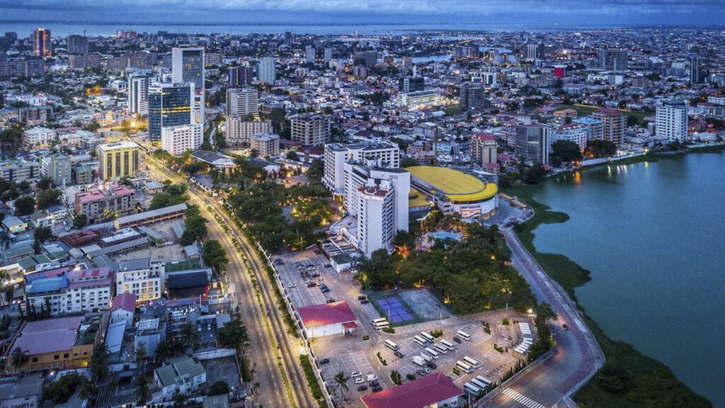

Stay Informed With the Latest & Most Important News
Previous Post
Next Post
Previous Post
Next Post
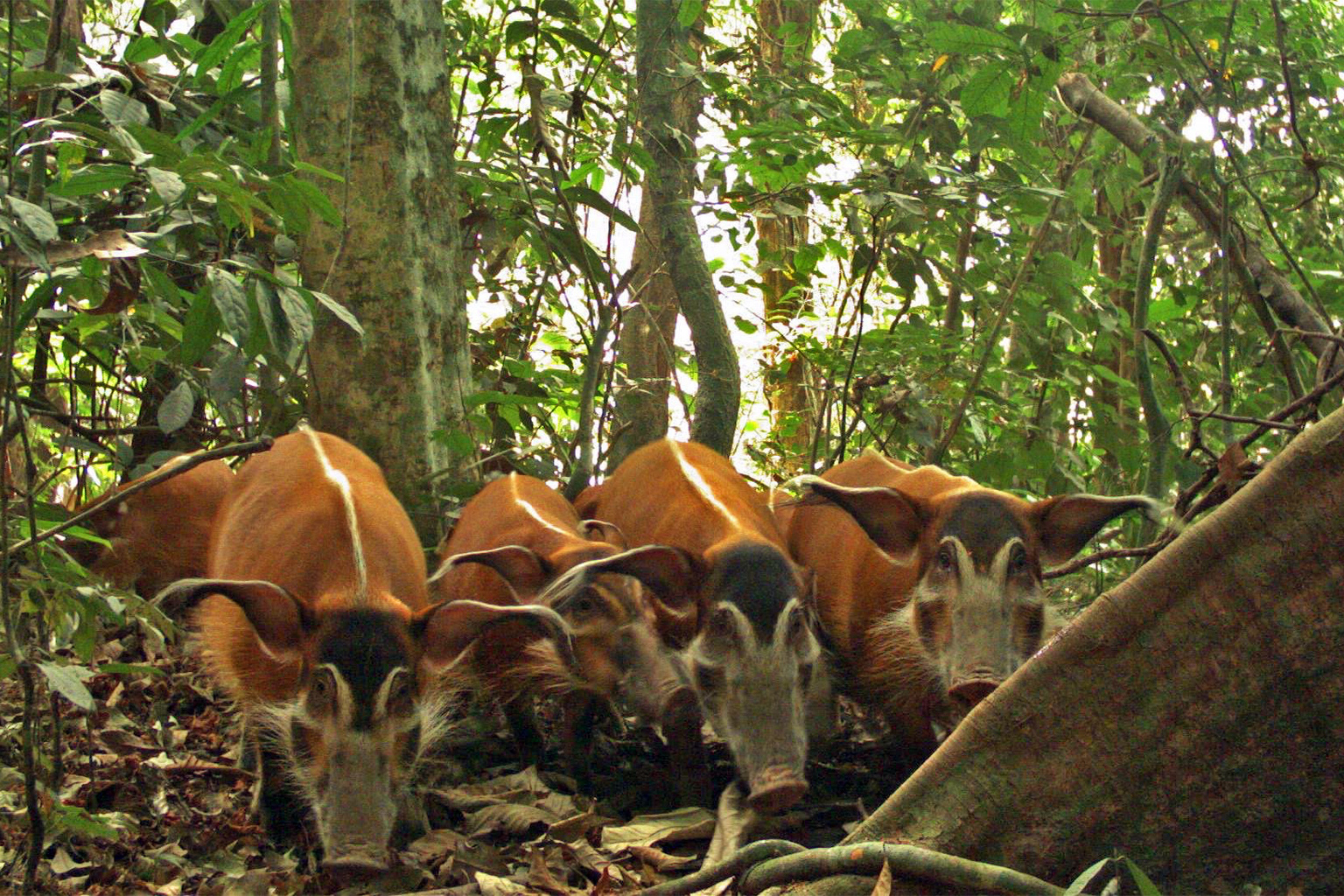
Advertisement