
Now Reading: The neighborhoods of Kano
1
-
01
The neighborhoods of Kano
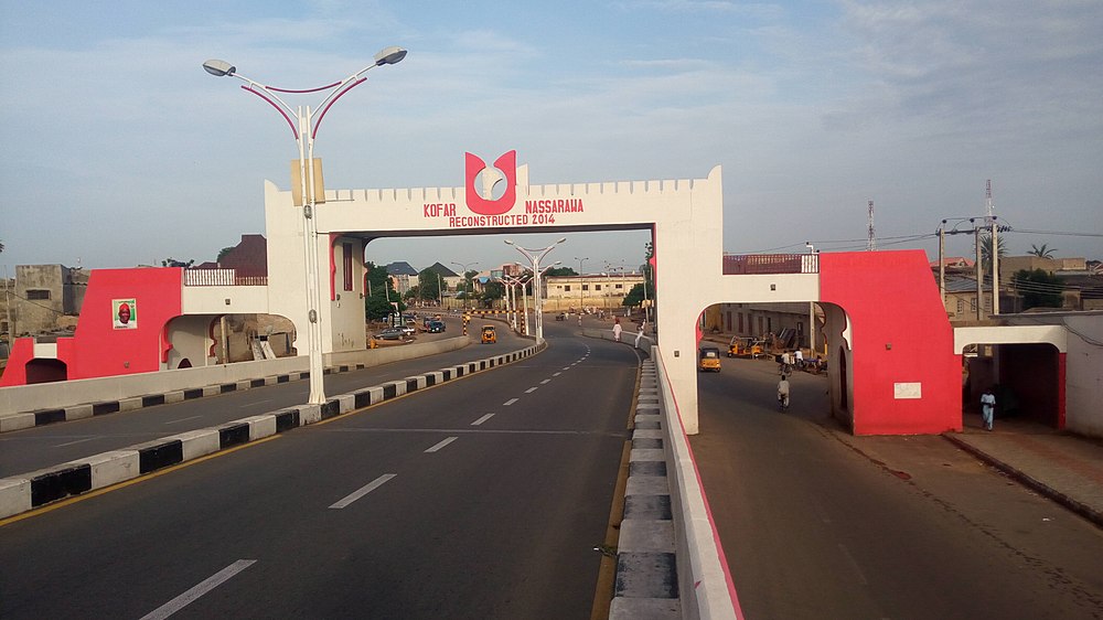

Kano is the largest city in Northern Nigeria and one of the oldest urban centers in West Africa, with over a thousand years of history as a commercial and cultural hub. The city is organized into old traditional quarters inside the ancient city walls and newer modern districts that expanded with colonial and post-colonial development.
Here’s an overview of the main neighborhoods of Kano:
🕌 Historic Inner-City Quarters (inside the ancient walls)
These quarters reflect Kano’s deep Hausa-Fulani history, centered around the Emir’s Palace (Gidan Rumfa) and old markets.
- Kofar Mata
- Known for its dye pits (Kofar Mata dye pits – one of the oldest in Africa).
- Traditional crafts and trading area.
- Dala
- Considered the spiritual and cultural heart of Kano.
- Dala Hill is believed to be the site of the earliest settlement in Kano.
- Gwale
- Densely populated, traditional residential quarter.
- Important in the history of Islamic scholarship in Kano.
- Kofar Wambai
- Famous for Kofar Wambai Market, one of the busiest in Kano.
- Kano Municipal Area (Old Kano City)
- Includes many ancient gates (Kofar Nassarawa, Kofar Dan Agundi, etc.).
- Bustling markets, mosques, traditional compounds.
🏙️ Modern Districts (Greater Kano Metropolitan Area)
- Sabon Gari
- “Strangers’ Quarters” established by the British for non-Hausa residents.
- Cosmopolitan, with Igbo, Yoruba, and southern Nigerian communities.
- Known for nightlife, shops, and churches.
- Fagge
- Commercial and residential district.
- Includes part of Sabon Gari and Kano Central Mosque vicinity.
- Tarauni
- Mix of residential estates and commercial activity.
- Nassarawa GRA
- Government Reserved Area (upscale).
- Hosts luxury homes, hotels, and offices.
- Hotoro
- Residential neighborhood on the eastern side of Kano.
- Known for military barracks (Dakata/Hotoro Barracks).
- Naibawa
- Busy gateway area along Kano–Zaria road.
- Known for Naibawa Motor Park.
- Kumbotso
- Peri-urban district with Kano University of Science and Technology.
- Sharada/Chalawa
- Industrial zones with factories and textile industries.
- Bompai
- Industrial and commercial district.
- Also hosts embassies, schools, and residential estates.
- Dorayi
- Residential and educational area (close to Bayero University, Kano).
- Rijiyar Zaki
- Densely populated residential area, popular with students.
- Yankaba
- Known for Yankaba Market (especially perishable goods like tomatoes and peppers).
- Kawo
- Residential and semi-urban district.
🌍 Greater Kano Satellite Towns
- Dakatsalle
- Rural-urban fringe, connected to Kano’s expansion.
- Gwarzo, Gezawa, Madobi, Kura
- Smaller towns around Kano that are increasingly integrated into the metropolis.
✅ Summary:
- Historic quarters: Dala, Gwale, Kofar Mata, Kofar Wambai, Emir’s Palace area.
- Commercial/industrial districts: Sabon Gari, Fagge, Sharada, Chalawa, Bompai, Yankaba.
- Residential/elite areas: Nassarawa GRA, Hotoro, Dorayi, Tarauni.
- Satellite communities: Naibawa, Kumbotso, Dakatsalle, nearby towns.










Related Posts

Stay Informed With the Latest & Most Important News
Previous Post
Next Post

Advertisement

Donations




Loading Next Post...


