Abuja The Federal Capital
Center of Unity · Government · Aso Rock · Planned City
Discover Abuja, the meticulously planned Federal Capital Territory of Nigeria, built from scratch to symbolize national unity and house the supreme seat of power.
The Center of
Unity
Abuja is the capital city of Nigeria, located in the center of the country within the Federal Capital Territory (FCT). Unlike the organic, centuries-old expansion of most Nigerian cities, Abuja is a meticulously planned metropolis, designed and built primarily in the 1980s. It officially replaced Lagos as the nation's capital on December 12, 1991.
The decision to move the capital was driven by the severe overpopulation and infrastructure strain in Lagos, as well as a strategic desire for a neutral, central location. Abuja was chosen specifically because it was not dominated by any of Nigeria's major ethnic groups (Hausa, Yoruba, or Igbo), reinforcing its motto as the "Center of Unity."
Today, the city is defined by its wide boulevards, impressive modern architecture, and the looming backdrop of Aso Rock—a massive monolith that lends its name to the Aso Rock Presidential Villa, the ultimate seat of Nigerian power located in the heavily secured Three Arms Zone.
- Design: The ambitious master plan was developed by the International Planning Associates (IPA), a consortium of American firms, with distinct architectural direction from renowned Japanese architect Kenzo Tange.
- Structure: The city is divided into phases, with Phase 1 containing the most developed and affluent districts like Maitama, Asokoro, Wuse, and Garki.
- Governance: Abuja is administered by the Federal Capital Territory Administration (FCTA), headed by a Minister appointed by the President.
The Capital in Numbers
A quantitative look at the FCT
Explore the Districts
The structured zones of the planned city
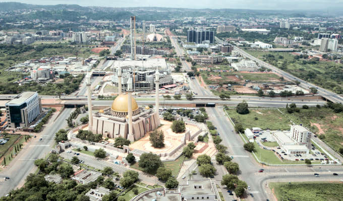
The Central Business District (CBD) of Abuja, featuring wide, planned avenues and modern administrative architecture.
| Aso Rock | A massive, 400-meter monolith dominating the city skyline; synonymous with the Nigerian Presidency. |
|---|---|
| National Mosque | An architectural masterpiece featuring a golden dome and four minarets, located on Independence Avenue. |
| National Christian Centre | The primary place of worship for Nigeria's Christian population, known for its striking neo-gothic design. |
| Zuma Rock | Located just outside the city limits in Niger State, this massive inselberg is often called the "Gateway to Abuja." |
| Millennium Park | A large, open park used for military parades, presidential inaugurations, and national day celebrations. |
History & Governance
The mechanics of the federal capital
Initiated by the military regime of General Murtala Mohammed, the decision to leave Lagos was based on its acute congestion, intolerable traffic, and lack of space for expansion. Abuja was selected for its central location, pleasant climate, and to serve as a neutral ground, free from the cultural dominance of any single ethnic group.
Unlike Nigeria's 36 states, Abuja does not have an elected Governor or a State House of Assembly. It is administered directly by the Federal Government through the Federal Capital Territory Administration (FCTA). The President appoints a Minister of the FCT to act as the chief executive of the territory.
While Lagos is the commercial engine, Abuja's economy is heavily driven by the public sector, government contracting, and the diplomatic corps. The city boasts a large expatriate community, high-end real estate, and a quieter, more structured lifestyle compared to the chaotic hustle of Lagos.
Abuja was designed to reflect modern power. Key architectural highlights include the Ministry of Defence headquarters (shaped like a ship), the massive Central Bank of Nigeria building, and the symmetrical alignment of the National Mosque and Christian Centre along the central axis, symbolizing religious harmony.
Phases & Development
Understanding the city's master plan
| Phase | Key Districts | Characteristics |
|---|---|---|
| Phase 1 | Central Area, Asokoro, Maitama, Wuse, Garki | The most developed; houses government HQs, embassies, and premium residential areas. |
| Phase 2 | Mabushi, Utako, Wuye, Gudu, Jabi, Katampe | Primarily residential and light commercial, accommodating the middle and upper-middle class. |
| Phase 3 | Gwarinpa, Galadimawa, Life Camp, Lokogoma | Rapidly expanding residential zones, featuring some of Africa's largest housing estates. |
| Phase 4 & 5 | Kuje, Lugbe, Mpape (Suburbs) | Ongoing development, serving as crucial satellite towns for the city's vast workforce. |
| Year | Event |
|---|---|
| 1976 | General Murtala Mohammed announces the relocation of the capital. |
| 1979 | The master plan for the city is formally approved. |
| 1980s | Intensive construction begins under President Shehu Shagari and continues under military rule. |
| 1991 | President Ibrahim Babangida officially moves the seat of government to Abuja. |
| 1999 | The Fourth Republic begins; civilian governance operates from the Aso Rock Villa. |
Administrative Data
See also & internal links
Go deeper